WEST VIRGINIA Index: Hampshire History, PARKERs, PARKER Timeline, PARKER Map
↳George PARKER, John PARKER, Job PARKER, Thomas PARKER
On this page:
• Research Notes
• George PARKER, b abt. 1700 and Descendants
• Benjamin PARKER, b. 1723, son of George PARKER
Latest update: Thursday, 06 February, 2014
Learn more about our PARKERs in the Family Tree Database .
NOTE
Although WEST VIRGINIA is used on this webpage for convenience,
WEST VIRGINIA was part of VIRGINIA until June 20, 1863.
• RESEARCH NOTES
• To date, there has been no documentation of more than one George PARKER in the Hampshire County area during the first
half of the 1700s. However, there were at least six (6) George PARKERs in Tidewater VIRGINIA, indicating George PARKER
was a prevalent and common name at the time.
• There was a John PARKER who appeared about the same time and same place as George PARKER, however DNA
comparison indicates John and George are NOT DNA RELATED.
• To add to the myth of their relationship, John PARKER's widow Elizabeth married again to Thomas McGUIRE,
who was one of the securities for the will of our George PARKER.
• In addition, a member of the George PARKER family and a member of the John PARKER Family married into the
Abraham JOHNSON Sr. family, who came to the Patterson Creek valley about the same time as the PARKER families.
However, we now know these marriages were not driven by familial ties but most probably by proximity.
• Abraham Sr.'s son William married Mary Catherine PARKER, granddaughter of John PARKER
(through Robert).
• Abraham Sr.'s great grandson Abraham (through William, Okey) married Susan Matilda PARKER,
George PARKER's 2G granddaughter (through Benjamin, James, James).
• In addition, the currently unrelated Job PARKER and family and the currently unrelated Thomas PARKER and family lived
within twenty miles of our George PARKER. Ancestors of these two additional PARKERs have yet to be tested and/or register
with the PARKER Family DNA Project, so there is no documentaton of the relationship of these two additional PARKER families
to George's family or John's family.
• During the first half of the 1700s, the Patterson Creek area now known as Hampshire and Mineral Counties, went through
the identity crisis of Essex County, Spotsylvania County, Orange County, Frederick County, Augusta County, until Hampshire
County was formed in 1753. XFor additional details, see Hampshire County Pedigree.X
• The 1754 - 1763 French Indian War, the 1776 American Revolutionary War, the War of 1812, the 1863 American Civil War,
and dozens of wars with native Americans before and in between these wars were all fought on the land of Hampshire County.
And all took their toll on documents of record. Add to the absence of historical records the common name of PARKER, and it is
little wonder the foundation of our family tree is choked with genealogical kudzu.
• Pioneer George PARKER (b.c. 1700 - 1757)
Descendants in .pdf
Map of places of George PARKER
Also, visit
• Early Settlers of Patterson's Creek
• Thomas 6th Lord Fairfax Royal Grants on Patterson Creek
George PARKER, born about 1700, was one of the earliest settlers of what is today Hampshire
County and Mineral County, WEST VIRGINIA. Although he probably lived on the land as early as
1740, in 1748 George purchased one of the first plots of land sold by Thomas 6th Lord Fairfax.
The survey of this land was assisted by the sixteen (16 ) year old George WASHINGTON. In
1755, during the French Indian War, young Colonel George Washington ordered a fort built on
[George] Parker's, Lot. No. 1 (although the fort may have been built about one and one-quarter
miles to the south). George married Ann, and they had one son who lived to adulthood. George
died during the French- Indian War, which was often fought on and around George's property. In
his will, George left his earthly possessions to his wife Ann and his son Benjamin.
To date there is no documentation of the birth date or birth place of our George PARKER.
The only documentation of the ancestors of George PARKER is found in the obituary of his 2X
great grandson James Thronton PARKER, "James Thornton was a member of the pioneer family
of Hampshire County, Virginia, near Romney on the Potomac River since 1740, whose original
American ancestor, Robert Parker, a grandson of the Earl of Macclesfield, immigrated to Virginia
in 1660." However, to date this claim has not been documented.
KUDZU: There is over a century of family tree kudzu that tries to suggest our George PARKER was from Tidewater VIRGINIA.
However, DNA and documents prove our George was NOT the son of Major George PARKER and Ann SCARBOROUGH,
NOR the son of John PARKER and Bridget SACKER nor any of the seven (7) contemporary George PARKERs from
Tidewater VIRGINIA. (See NOT our George PARKER.)
DOCUMENTED: According to his will, our George married Ann.
KUDZU: Many of the researched family trees record George's wife as Ann MAJORS by using the marriage of "George Parker
to Amie Major, 18 Dec 1721 in Northampton County, VIRGINIA." (Ancestry.com Transcript) However, Northampton County,
VIRGINIA was in Tidewater VIRGINIA, and this marriage was of one of the TidewaterVA George PARKERs, NOT our George
PARKER.
• DOCUMENT: A transcription of the Marriage Bond indicates the marriage bond was between George PARKER
and William MAJOR, sealed 10 Dec 1721, for a marriage between George PARKER and Amie MAJOR in
Northampton County, Colony and Dominion of Virginia. (Image of Marriage Bond transcript is available at the
Ancestry.com tree of Lane&Shiling)
"Children of John Parker (5Q) and Bridget Sacker Parker (5Q1) ... George Parker (6AL) born ca. 1698 will
written 18 July 1748 in Accomack County, Virginia married 18 December 1721 in Northampton County, VA to
Amy Major (6AL1)76 born ca. 1703 in Northampton County, VA died before 23 Feb 1768 in Accomack County,
VA77. She was the daughter of John Major78 and Ellen E. Major and was some times called 'Naomi'."
(Descendants of George Parker By James R. Revell, Sr. -- GHOTES)
• Additional KUDZU: The Miles Files has "Amey 'Naomi' Major1 F, b. circa 1700, daughter of John Major b. c 1674,
d. b 9 Apr 1734, married on 18 December 1721 at Northampton Co, VA." as being married to yet another George
PARKER of Tidewater VIRGINIA, "George Parker (Parkers Creek)1 M, b. circa 1693, d. before 29 November 1748,
(Miles Files) Father George Parker Sr. (Parkers Creek) b. c 1660, d. b 7 Jul 1713, Mother Mary (-----) b. c 1660"
DOCUMENTED: Ancestry.com's English Duplicates of Lost Virginia Records: List of Patents, records George PARKER and his
partners as "licensed" with 10,000 acres in Spotsylvania County. (NOTE: in 1720 Spotsylvania County included land that
became Hampshire County in 1753.)The "Extract out of the Council Journal" is dated 23 December 1720. This document does
not indicate how much of the 10,000 acres belonged to George nor if or when George occupied the land in Spotsylvania
County. In George's will there is no mention of this land. This may NOT be our George PARKER.
(115)
EXTRACT OUT OF THE COUNCIL JOURNAL of the 23rd December 1720 of the Quantity of Land licensed to be taken
up in the County of Spotsylvania
[Name] Acres
Richard Hickman, Gen. & his partners 20000
Robert Carter Esq. 3500
Cole Diggs, Peter Beverly Esq. & Wm. Robertson Sr. 12000
William Bassett & Garvin Corbin Esq. 15000
Augustine Smith and Lawrence Smith 10000
Robert Brook Jr., Augustine Smith, Will'm Brook,
Humphrey Brook and George Braxton 8000
Garvin Corbin Esqr. 3000
John Bagg** 10000
George Parker & his partners 10000 [10,000 acres]
Signed by Wil: Robertson, Cl. Com.
DOCUMENTED: To date, there is only documentation to support one child, who grew to adulthood, for George and Ann.
Although we have yet to see the documentation, the DAR (Ancestor#: A087335) and SAR have applications that indicate
Benjamin PARKER was born 1722/23. Some family trees indicate Benjamin was born in Hampshire County and some
indicate he was born in Spotsylvania County; since Hampshire County was part of Spotsylvania at the time, both locations
could be the same location. As additional documentation, George's will leaves his assets, including his Fairfax Grant Patterson
Creek land to his wife Ann and his son Benjamin.
DOCUMENTED: As early as 1740, a PARKER family lived "near present-day Romney." This is the land surveyed by GENN in
spring of 1748."(Earliest European Settlers; Hampshire County, West Virginia @ Wikipedia)
"During the early 1700s, several fur traders and explorers were known to have traveled through Hampshire
County, but their names were not recorded. By 1735, six families had settled in the Springfield area, including
the families of James Howard, John and James Walker, Jonathan Coburn, James Rutledge and a Mr. Forman
(possibly William). In 1738, John Pearsall (or Pearsoll) and his brother Job built cabins near present-day Romney.
It was reported that Job paid Lord Fairfax five shillings for his 323-acre homestead. Initially, their settlement was
known as Pearsall's Flats. Within a few years, they were joined by the following seven families: Blue, Good, Hunter,
Johnson, Kuykendall, Parker, and Rodgers. By 1748, nearly 200 people lived near Pearsall's Flats."
(Hampshire County History, Department of Political Science, West Virginia University)
DOCUMENTED: In spring of 1748, Thomas Fairfax, 6th Lord Fairfax of Cameron sent a surveying party, including 16 year-
old George Washington, to survey his lands along the Potomac and South Branch Potomac rivers. This resulting surveyed
map was considered lost until the research of Wilmer L. KERNS, Early Settlers of Patterson's Creek.
"Lot #1 [See map above] George Parker's house was located on the east side of Patterson's Creek, near a
small and unnamed stream. The major road between Winchester and Patterson's Creek came directly to
Parker's farm {passed through Parker's farm} George Washington referred to Parker's farm as a "plantation."
Fairfax issued a grant to Parker on Oct. 25, 1748. Lot #1 adjoined the Patterson Creek Manor [not to be
confused with Patterson's Creek settlement] The community of Headsville, Mineral County, WV is located
on Parker's former land. Parker died in 1757 and his oldest son Benjamin (1722-1804) inherited his estate
of 399 acres. (Early Settlers of Patterson's Creek)"
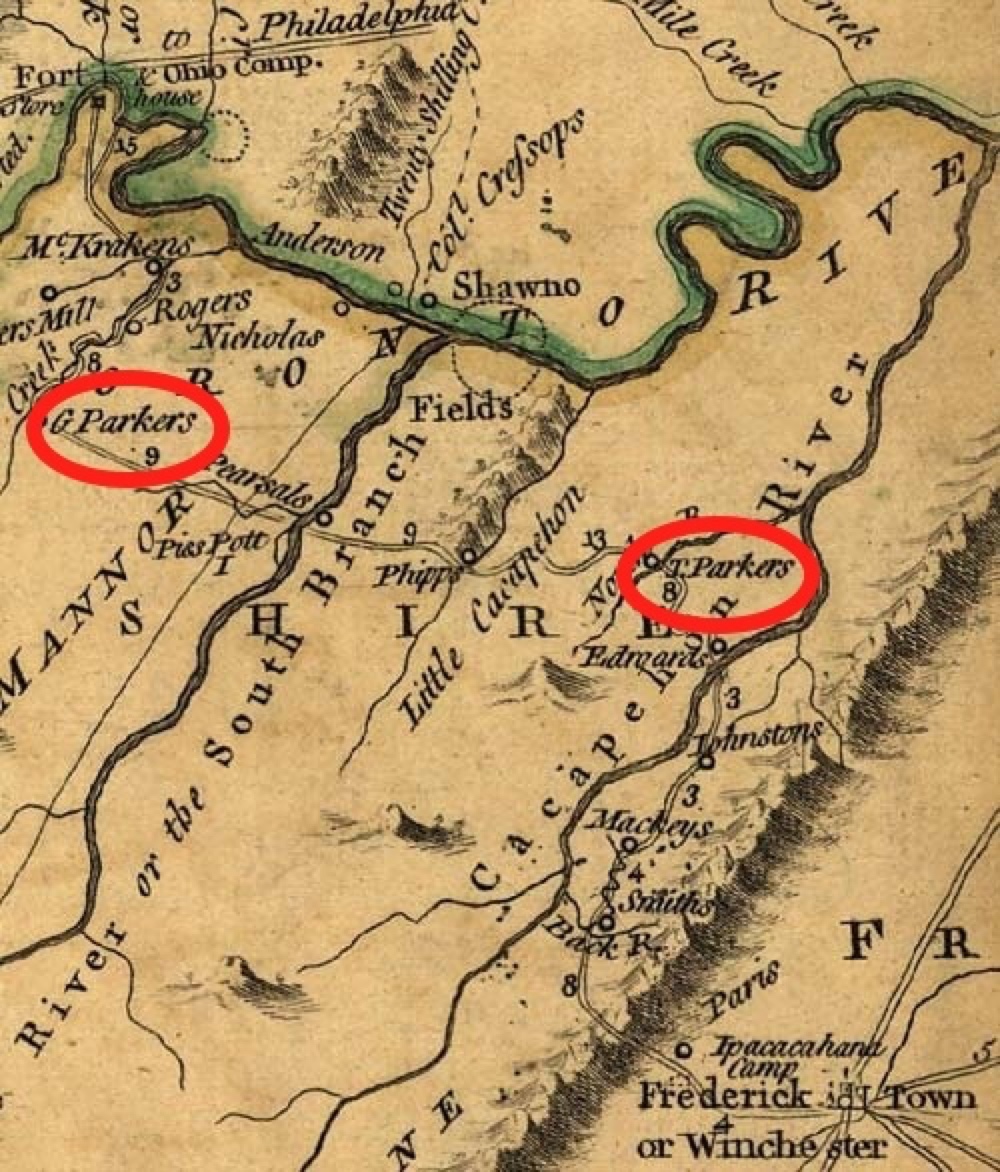
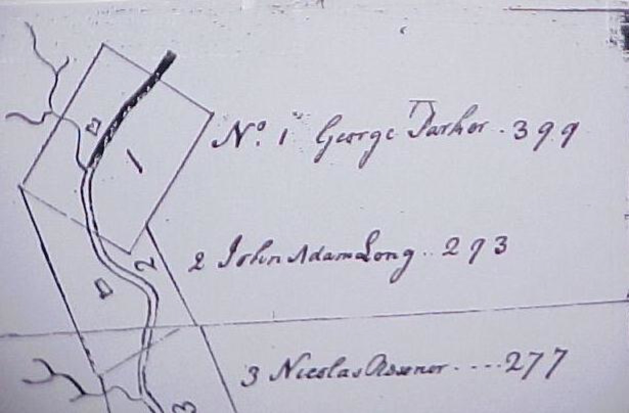
DOCUMENTED: On 25 October 1748, our George PARKER bought Lot No. 1 of 399 acres of the Lord Fairfax Royal
Land Grant. For location, description, sources and maps of the Lot, see Fairfax Grants on Patterson Creek.
NOTE: In the entry below from "Virginia Northern Neck Land Grants, 1742-1775, Volume 2" by Gertrude E. GRAY George
PARKER is "of Frederick County."
• "To add to the confusion, parts of the Fairfax grant in this area lay in Frederick County (north of the Trough), and
those south lay in Augusta County. Since leases for this land was considered a private transaction with Lord
Fairfax, they were not generally recorded in the county deed books, though references can be found in Hampshire,
Hardy, Frederick and Augusta County records. Many of the Northern Neck land records are available at the
Virginia State Library and the Library of the West Virginia Department of Archives and History. A few published
abstracts of Northern Neck warrants, surveys and grants are also available, specifically in works by Peggy Shomo
Joyner and Gertrude E. Grey." (Men and Manors, In the South Branch Valley @ WVGenWeb)
• "G-137: George Parker of Frederick Co. 399 A. Surv. Mr. James Genn. On Patterson's Cr.of Potomack R. Tract
No. 1. Adj. the Manor line. 25 Oct 1748" Book G, page 29 (Virginia Northern Neck Land Grants, 1742-1775. Vol. II
@ Ancestry.com, sourced) "Introduction. As settlers moved west from the Tidewater area of the Northern Neck
and south from Maryland, Pennsylvania and other northern colonies, new counties were formed in the
Shenandoah Valley are of Norther Neck. The time period covered by the grants abstracted herein includes formation
and settlement of Frederick, Fairfax, Culpepper, Loudoun, Fauquier, and Dunmore (changed in 1778 to Shenandoah)
counties in Virginia and Hampshire and Berkeley counties, now in West Virginia… Many land grants are given
as 'of Frederick County,' for Frederick was the parent county of many others, and grants were issues before
the population was sufficient to form new counties." (page VII, Virginia Northern Neck Land Grants, 1742-1775.
Vol. II @ Ancestry.com, sourced)
NOTE: John PARKER also purchased one of these first lots in the Fairfax Land Grants - - 312 acres, Lot No. 12, June 8, 1749.
In addition Abram JOHNSON purchased on of these first Fairfax Lots -- 293 acres, Lot No. 5, Oct. 26, 1748. The JOHNSON
family married into the John PARKER family.
DOCUMENTED: Patterson's Creek settlers petitioned the Frederick County Court on on Aug. 8,1749 for construction
of two roads leading to their settlement: (1) From the mouth of Patterson's Creek to Job Piersall's (at "Romney")
and (2) for a road that leads from Lower Patterson's Creek past Power Hazel's lot #8 to the wagon Road
on Col. Parker's lot #1 to the Wagon Road that leads from Winchester to the South Branch. These two roads
would not only inter-connect the settlers along Patterson's Creek, but would allow travel to the courthouse in
Winchester and create a gateway for trading. (WVHAMPSH-L Archives)
Petitioners for first road:
Road Order "FC, 3:119-20, 8 August 1749
"On the petition of Solomon Hedges, Abraham Richardson, Benjamin Parker, George Parker, Jr., John Radden,
John Reon, Abraham Johnson, Theodore Davis, Isaac Johnson, Adam Warner, Robert Lowder, Vincent Williams,
James Patton, George Corn, John Dowthen [Douthitt?], Abraham Fegurden, Adam Stomp [Stump], John Adam Long,
Christana Long, Gilles Sullivan, John Cockendal, Benjamin Cockendal, Nathaniel Cockendal, Abraham Cockendal,
Abraham Cockendal Jr., John Cockendal [Jr.?], Peter Cockendal, David Thomson, Frank Thomson, Matthias Foman,
James Cockendal, John Decker, Luke Deker, William Earles, James Hannen, Henry Vanmetre, Andrew Nowland,
James Williams, Benjamin Horman Jr., Richard H[?]land, John Colvin, Joseph Campbell, John Cinacome, Job Pearsall,
William Buffington, David Oneal, and Garret Decker for a road from the mouth of Patterson's Creek to Job Pearsall's. I
t is ordered that Nicholas Raisner [Reasmer?] and George Parker view, mark, and lay off the same, and when laid off,
that the petitioners clear and work on the same under the said Raisner and George Parker, who are hereby appointed
overseers thereof. And it is further ordered that the said Nicholas Raisner and George Parker cause the said road to be
kept in good repair according to law." (Colonial Hampshire County Road Orders by Terry Gruber @ WVGenWeb)
Research Note: To date, this first reference to "George Parker Jr." is the only reference to a "George PARKER Jr." during the
first half of the 1700s in the area of Hampshire County. There are four possible explanations: our George PARKER was a Jr.
but dropped the Jr. except for this reference; our George PARKER had a son George Parker, who did not live beyond this
reference; the addition of Jr. was an original recording error; the addition of Jr. was a transcription error. A study of the
additional names in this road order and of the road order assignment of George Parker as marker, overseer, and maintenance
manager and of the names of the others who purchased Fairfax Grant Land the same time as George PARKER could lead to
the extrapolation that "George PARKER Jr." was actually our George PARKER.
DOCUMENTED: "FC, 3:294, 14 August 1750
"On the motion of Power Hazel and George Parker, it is ordered that all tithables from the mouth of Patterson's Creek
upwards and also the tithables on the North Branch above the mouth of Patterson's Creek upwards (meaning the
Potomac River, known as the North Branch of Potomac) work on the road from the said Creek to Job Pearsall's as
formerly laid off." (Colonial Hampshire County Road Orders by Terry Gruber @ WVGenWeb)
DOCUMENTED: Son Benjamin PARKER married Margaret THORNTON on 18 Jun 1752, in what is now Hampshire County,
WEST VIRGINIA.
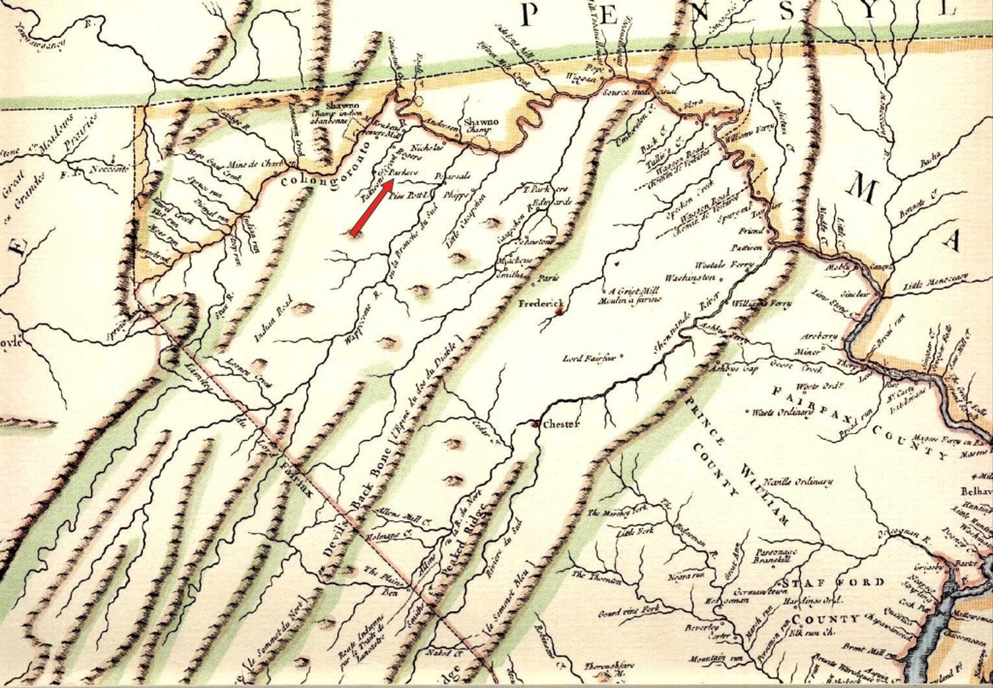
DOCUMENTED: The "Parkers" land is noted on the 1755 Fry-Jefferson Map of Virginia. Select the map above for a larger
image and note the red arrow. ("CARTE de la VIRGINIE et du MARYLAND, A portion of the Fry and Jefferson Map, 1755" by
"When the Board of Trade and Plantations requested information concerning activities on the frontier, Lewis Burwell,
acting governor of Virginia, commissioned Colonel Joshua Fry and Peter Jefferson to prepare a map of the colony.
Fry and Jefferson were experienced surveyors who had worked together in determining the Fairfax Line in 1746 and
who also had served as joint commissioners to extend the western portion of the boundary line between Virginia and
North Carolina in 1749. They worked also as surveyors for Albemarle County, a recently created county in Virginia’s
Piedmont region. The pressure to produce the map compelled Fry and Jefferson to rely on their own surveys and
experiences to supplement existing published maps, manuscript maps, and field notes. In 1751 Fry and Jefferson
delivered a draft to Burwell, who then forwarded it to the Board. Fry and Jefferson’s published map dominated
cartographic representations of Virginia until the publication of Bishop James Madison’s map in 1807. In their map,
Fry and Jefferson included their completed border survey for the western bounds of the Northern Neck and of part
of the dividing line between Virginia and North Carolina. For the first time the entire Virginia river system was properly
delineated, and the northeast-southwest orientation of the Appalachian Mountains was fully displayed, although
John Lederer had suggested that alignment, even without the benefit of surveys, as early as 1672.
(The Fry-Jefferson Map of Virginia; Fort Edwards.org; American Memory)
DOCUMENTED: In information from the "JC Sanders Papers" summarized in "EARLY SETTLERS OF THE PATTERSON
CREEK VALLEY" @ WVGenWeb, documents the PARKERs in Patterson Creek. (JC Sanders was a teacher and amateur
historian in Mineral County.)
[quote]
"These papers reveal rather conclusive evidence that some of the Johnson family, probably either William or
Abraham, were connected in some official way, manager or patent, of the Ohio Company whose Ware-houses and
store stood on the river bluff at Ridgeley from 1750 till about 1755 when the VA Colonial Government took it and
converted in into a Fort. Among these Johnson papers is an account of this Ohio Company with Abraham Johnson
through William Johnson…"
"From these papers we glean that the following families were settlers in the Patterson Creek Valley and the region
between Fort Ashby and Fort Ohio previous to 1750: JOHNATHAN ROLFE, THOMAS HARDING, WILLIAM HONSON,
ABRAM JOHNSON, OKEY JOHNSON, SOLOMON HEDGES, ROBERT ALLEN, THOMAS CHESTER (sheriff of
Frederick Co 1745), QUINTIN MCCOLME, JAMES COLWELL, MARK WEBSTER (manager of Ohio Co 1750),
ALEXANDER CAMPBELL, SAMUEL LOCKHART, THOMAS ROSS, SAMUEL CANAL, NICHOLAS REASONER, RICH
WILLIAM, NATHANIAL COOPER, EZEKIAL MULFORD, JOHN DECKER, JOHN KUYKENDALL, BENJAMIIN
KUYKENDALL, HUMPHREY BROOK (Clerk of Hampshire Co 1754), WILLIAM ANDERSON, RICHARD POLSON,
MATTHEW ROGERS, NUNIGENS, STRADOLDS, RAY.
"From other sources we gather the following residents of that section at that time: ELIAS SELLER, THOMAS SELLERS,
JOHN ASHBY, PARKER, EDWARDS, MCGUIRE, MACGRIGGEN, WISE, KELLER AND WAGANOR
[end quote]
Research Note: This PARKER could be John PARKER, who married into the JOHNSON Family.
DOCUMENTED: However challenging life was when George bought his land, life became much worse in the late summer and
early fall of 1755, when Patterson Creek valley was devastated by the defeat of Braddock's force at the hands of the French
and their Indian allies at the Battle of the Monongahela, (also known as the Battle of the Wilderness) in early July 1755. This
early defeat of the The French Indian War, (1754 to 1763] left the Virginia frontier at the mercy of hostile bands of native
Americans.
• The book "Early Land Grants and Settlers Along Patterson Creek" [excerpted and edited] does an excellent
job of describing what life was like for our George and his family on his Patterson Creek property.
[quote]
Patterson Creeks unique chapter in history was made during this struggle. [George] Washington's diaries and
letters provide the most authentic source of information on events during these tragic years along the frontier. His
entries were sometimes based on reports that he was unable to verify, but he sensed the terror of the settlers and
felt the despair of a military man who is helpless to avert the cruelties of war from being inflicted on a civilian
population.
The young colonel [George WASHINGTON] planned a line of forts extending from Fort Cumberland, in Maryland,
southward to the North Carolina border.25 The two northernmost forts were along Pattersons Creek, which in his
list he designated as Fort at Ashby's and Fort at Cocke's. These he judged to be twenty miles "distance from each
other.
[In Ashbys Fort: Defending the Colonial Frontier by Terry Gruber, Fort Ashby is just across Patterson
Creek from "Parker" land.]
Washington considered Reasner's plantation, which was on Lot. No. 3, as a possible site for the defensive fort [but]
he later ordered [the fort] built at [George] Parker's, Lot. No. 1. [Although Parker's Lot No.1] was designated by
Washington as the site of a defensive fort to be garrisoned by Captain William Cocke's company of the Virginia
Regiment... the fort may have been built about one and one-quarter miles to the south on a hill on the east side of
the Creek. This would have placed it within Lot No. 12 of the Patterson Creek Manor. [Fort Cocke]
From Pearsall's fort, near Romney, he [WASHINGTON] wrote to Captain William Cocke, on October 23, 1755: "You
are hereby Ordered to remove with your Company from the place where you are now Quartered, to the Plantation of
Nicholas Reasmer, in order to . . . protect the inhabitants, by sending out frequent Scouting Parties." On the same day
he wrote to his friend, George William Fairfax, "We arrived here today, where I met Captains Cocks and Ashby, whom
I have appointed to remain on Pattersons Creek; the one at Nicholas Reasmers, the other at Seller's in order to
protect the Inhabitants"
Three days later, from Fort Cumberland, he wrote to Lieutenant Bacon of the Maryland Independent Company,
"You are to proceed to George Parkers Plantation, where you will meet with Captain William Cocks and his Company
of Rangers, who are ordered to erect a Work of Defense at the said place." It was to be a quadrangular fort of ninety
feet, with bastions. Another fort of the same dimensions was "to be built by Captain Ashby's Company, at the Plantation
of Charles Sellers, or the late McCrackin . . ." whichever was judged to be the most convenient."
The isolation that had been, and to some extent still is, the splendor of the upper Potomac valleys, now became a
part of their tragedy. By the spring of 1757 the two garrisons on Patterson Creek were withdrawn to the South
Branch.... The settlements along Pattersons Creek were particularly vulnerable... E. L. Judy in his History of Grant
and Hardy Counties lists fifty or so names of settlers killed in what was then Hampshire County. In addition, there
were more than thirty wounded or taken prisoner. From this and other sources it is possible to identify perhaps seven
of these casualties as having occurred along Pattersons Creek, but Washington's writings lead to the melancholy
conclusion that there were more.
[end quote]
• Journal Of Captain Charles Lewis Of The Virginia Regiment, Commanded By Colonel George Washington
In The Expedition Against The French, October 10 December 27, 1755
[quote]
page 208
October 27th A very wet day. We marched to Patterson' s Creek, on which we encamped, in a house deserted.
We found here good corn, wheat, and pasturage. Before we marched we discharged our pieces, being wet, and
charged them, in expectation of seeing the enemy. Colonel Washington marched before with Captain Ashby's
company of Rangers. Fourteen miles.
October 28th Marched from Patterson's Creek. Passed many deserved houses. I was this day very curious in
the examination of the mischief done in the houses, and was much shocked at the havoc made by the
barbarous, cruel Indians at one Mecraggin's. [James McCracken, Fairfax Grant Lot 17, near Ft. Ashby] I found
the master of the family, who had been buried but slightly by his friends after his assassination, half out of the
grave, and eaten by the wolves; the house burnt, the corn-field laid waste, and an entire ruin made. At half-past
6 we arrived at Fort Cumberland, cold and hungry.
page 210
November 20th Ensign Bacon arrived at the fort from Patterson's Creek, where he had been to erect a fort.
On his way he heard the Indian Hallow, and saw many tracks of Indians in the woods. This alarmed the fort,
but being late 'twas not possible to send out a party; but orders were given for a hundred men to parade in the
morning under Captain Waggoner.
November 21st A very bad morning, wet and continuing to rain. A party of one hundred men paraded under
Captain Waggoner, to search for the Indians on Patterson's Creek, according to Ensign Bacon's information of
the day before. Major Andrew Lewis and myself went as volunteers on this command. We returned the same day
with the party. No Indians or tracks of Indians to be seen.
[end quote]
Collections of the Virginia Historical Society, New Series. Vol XI. Proceedings of the Virginia Historical Society at
the Annual Meeting Held December 21 - 22, 1891 with Historical Papers Read on the Occasion, Edited by R. A. Brock
Archive.org, GoogleBooks, WVGenWeb
• In the chapter "The Brazen Throat of War" from his book “Frontier Forts Along the Potomac and Its Tributaries,”
William H. ANSEL, Jr. also does an excellent job of chronicling the French Indian War and it devastation on
settlers of the frontier.
• FORT COCKE from “Frontier Forts Along the Potomac and its Tributaries” by William H. Ansel, Jr.
[quote]
This defense was first known as Fort “G. Parker,” but it later took the name of Captain William Cocke of the Virginia
Rangers, as he was the commanding officer of the place during much of the Indian troubles. The fort was constructed
on the east side of Patterson’s Creek, on a knoll overlooking the bottom lands, about one mile south of present
Headsville in what is now Mineral County, West Virginia, formerly Hampshire County, Virginia.
This fort was built by Captain William Cocke’s third company of rangers under the direction of Lieutenant Bacon upon
orders of Washington dated October 26, 1755, and was probably completed within a month. The stockade, made of
upright logs or palisades, was in the form of a square ninety feet on a side and enclosed about one-fifth of an acre.
Bastions or blockhouses were built at each of the four corners. A barrack sufficient to house fifty men was constructed
within the stockade.
Washington ordered Lieutenant Bacon to proceed to “George Parker’s plantation where you will meet with Captain
William Cocke and his company of Rangers who are ordered to erect a Work of Defense at the said place.” George
Parker was the owner of Lot No. 1 of the Patterson Creek survey, it having been conveyed to him by Thomas
Lord Fairfax on the 25th day of October, 1748. The lot consisted of 399 acres and included what is now the
present site of Headsville. But in locating the fort, Bacon and Cocke selected a place within the bounds of the
Patterson’s Creek Manor land and more than one-half mile south or upstream of the southern boundary of Parker’s
Lot No 1. The survey of he Manor land into lots in 1762 by Joseph Neville placed Fort Cocke on Lot No 13 thereof.
At the time of the survey, Neville found Nicholas Seavours occupying this lot.
On November 9, 1756, the strength necessary to garrison Fort Cocke was listed at 500 men, while that necessary at Fort
Ashby was only 60 troops. But Fort Cocke, because of its size and location, at no time ever had a garrison that even
closely approached 500 troops. On May 14, 1756, the soldiers at this place were listed as one captain, one lieutenant,
one ensign, two sergeants and forty-five men. On July 13, 1756, Captain Robert McKenzie was ordered to proceed to the
fort “now commanded by Captain William Cox” to take command of it and to escort wagons to Fort Ashby on the one hand
and to Fort Pearsall on the other. McKenzie, with Cocke’s company, was further ordered to go out frequently and “scour
the woods well” in search of Indians.
On August 5, 1756, in orders to Captain Thomas Waggoner, Captain Bell was directed to Fort Cocke, to take command
there with twenty men and to escort all expresses and wagons going to and from Fort Cumberland as far as Ashby’s and
Pearsall’s. The remainder of his force was to be divided between Forts Kuykendall and Ashby. Located not far from the
mouth of Beaver Run, Fort Cocke was thus situate on or near the military road leading from Winchester to Cumberland,
and its garrison escorted wagon trains moving between the two places as far east as Romney and as far as Fort Ashby
to the north. Fort Cocke was attacked by a band of Indians in early April, 1756, but the garrison beat them off with no
loss. On the 3rd day of April 1756, John Adam Long, [Early Settlers] who owned Lot No. 2 of the Fairfax Patterson
Creek Survey about two miles north of Fort Cocke, was captured by the Indians who had attacked the fort and
he
was taken to Fort Duquesne. Long was then fifty-five years of age. He was at the French fort for twenty days when he
managed to escape and reached his home in safety. He took time, however, to stop at Fort Cumberland and report his
adventures to Colonel Adam Stephen.
In 1761, Windle Millar was killed by the Indians while working in a field near Fort Cocke. He left his widow,
Elizabeth, five sons and four daughters surviving. Millar was buried along the Creek at the place he was shot. At the
same time, Patrick McCarty was captured by the same Indians who had killed Millar. He was taken to Ohio and
burned at the stake by his savage captors. He left surviving his widow, one son, Colonel Edward McCarty, and four
daughters. A monument marks the place where these two settlers were attacked. It is uncertain when and by whom
this stone was erected, but it has been there for more than one hundred years.
In correspondence of Washington, Fort Cocke was mentioned many times. On January 10, 1756, in orders to
Commissary Thomas Walker, three months provisions were directed to be laid in at the fort, and since there were three
thousand pounds of pork stored at Fort Pearsall, a portion of this meat was directed to be taken to the Patterson’s Creek
fort. Not long after, Captain Cocke wrote Washington advising that Indians were lurking around his fort. Upon learning
this new, the militia from Louisa and Stafford counties assembled at Fort Loudon and destined for service on Patterson’s
Creek, deserted in droves, only six of the Louisa and eight of the Stafford County men standing firm.
On October 21, 1775, before the construction of Fort Cocke had begun, four officers, two sergeants and 29 rank and file
were stationed on Patterson’s Creek at or near the place where the fort was to be built. A short time after construction of
the place, on December 29, 1755, a captain, lieutenant and 27 men were stationed there.
George Parker, who lived about one mile downstream from this fort, furnished supplies from time to time to
Captain Cocke’s men. In March 1756, the Virginia Assembly allowed him the sum of 510 lbs of tobacco for two
hogs, and he was also paid 1 pound, 16 shillings and 3 pence for a cow delivered to the troops.
In March 1756 the Colony of VIRGINIA made a Legislative Enactment in order to pay participants for their effort
in the French Indian War.
'page 23
Legislative Enactments
That connect the preceding historic sketch with the adjudication of the resulting accounts which follow.
Act of Assembly State of VA., March 1756
for making provisions against invasions and insurrections, &c., and for raising the sum of of twenty-five
thousand pounds, for the better protection of the inhabitants on the frontier of this Colony, and for the
purposes therein mentioned. Henings's Statutes, Vol. 7, Page 26.
page 85
The following claims from the County of Hampshire, Hening's Statutes, Vol. 7, page 25, viz.:
To George Parker, for two hogs, 510 Lbs. tob.
page 86
To George Parker, assignee of James Fowler, for one cow, 1L 16s. 3d.
'
Gleanings of Virginia History,W. F. Boogher, 1903 @ Archive.org]]
Because of its small size, Fort Cocke was a place of limited refuge for settlers living in the Patterson’s Creek
Valley. After the capture of Fort Duquesne, troops garrisoning the fort were gradually withdrawn. Thereafter, it
deteriorated
rapidly. In 1770 while on a visit to his western lands, Washington rode down Pattersons Creek and stated that he stopped
at the place where Fort Cocke had stood, indicating thereby that within fifteen years of construction, it had ceased to exist.
(WVGenWeb)
[end quote]
• "{Fort Cocke] was constructed south of George Parker's land. This was on Lot 13 of the Lord Fairfax's Patterson Creek
Manor. The fort was constructed on the east side of Pattersons Creek, on a flat terrace above a rocky shelf overlooking
the creek bottom, about 1.5 miles (2.4 km) south of present Headsville, West Virginia." (Wikipedia)
• Capt. William Cocke's Fort , (1755 - 1760), near Headsville
"A settlers' fort that was used by the VA colonial militia after 1756. It was a stockade with four blockhouses and a 50-man
barracks. It was also known as George Parker's Fort. Attacked by Indians in 1756. George Washington referred to this
post as Fort Washington until 1758. Located one mile south of town on the east-side of Patterson Creek."
DOCUMENTED: Our George PARKER died after 27 February 1757 (the date of his will) and before 13 December 1758
(the date his will was proved) and during the French Indian War. With the above description of life just before he died, it
would be easy to extrapolate George was a direct or tangential victim of the war. George was about sixty years old and died
before the birth of his first (documented) grandchild, James PARKER, born 12 July 1759 in Middleton, Frederick Co,
MARYLAND about a hundred miles east of the PARKER's Patterson Creek homestead.
George left "Land on Patterson Creek; Fairfax Grants" to "W. [wife], Ann. Son, Benjamin." For copy and transcription of
document, visit Will of Our George PARKER.
[end George PARKER]
• Benjamin PARKER
From birth to probated will, documentation of George's and Ann's son Benjamin is much more prevalent and available.
Benjamin and two of his sons were enumerated in the First Census of the United States, 1782, in Hampshire County,
• Benjamin and his wife Margaret THORNTON were enumerated as "Parker, Benja, 6"
• Daughter Elizabeth's first child who lived to be recorded was not born until 1785, so Elizabeth was probably at home.
• Son Absalom, b 1764, married in 1786, so he was probably at home.
• There are two or three others enumerated who were either not family, extended family, or children of Benjamin
and Margaret who did not live to be recorded.
• Son James, his wife Rebecca WOLFE and their first child Absalom b. 1782 were enumerated as "Parker, James, 3"
• Son George and his family of 6 were enumerated "Parker, George, 6" and living "next door" to his father Benjamin.
Two years later in the 1784 Census for Hampshire County only two of George's kin were enumerated.
Name of head of family / White souls / Dwellings / Other buildings
• "Parker, Benjamin 5 / 1 / 2" was the enumeration for son Benjamin PARKER, wife wife Margaret THORNTON, probably
children Elizabeth, Absalom, and two or three others enumerated who were either not family, extended family, or children of
Benjamin and Margaret who did not live to be recorded.
• "Parker, James / 3 / 2 / --" was the enumeration for Benjamin's son James, wife Rebecca WOLFE PARKER, first child
Absalom, born Nov. 1782,
• However, Benjamin's son George and family were not enumerated.
The only confusion following the documentation of Benjamin is Benjamin PARKER son of Job PARKER, who was born, raised
a family, and died in Hampshire County, WEST VIRGINIA about the same time in as our Benjamin.
Many of Benjamin's children and grandchildren left WEST VIRGINIA and pioneered OHIO, INDIANA, ILLINOIS and beyond.
[end Benjamin PARKER]