WEST VIRGINIA Index: Hampshire History, PARKERs, PARKER Timeline, PARKER Map
↳ General History, Early Settlers, FAIRFAX Grants, Life and War
On this page:
• General History of Hampshire County, VIRGINIA / WEST VIRGINIA
• Hampshire County Pedigree
• Patterson Creek
Latest update: Sunday, October 7, 2012
Learn more about our PARKERs in the Family Tree Database .
NOTE
Although WEST VIRGINIA is used on this webpage for convenience,
WEST VIRGINIA was part of VIRGINIA until June 20, 1863.
• General History
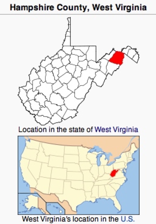
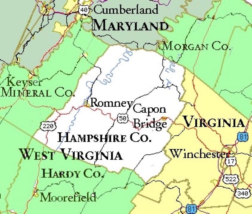
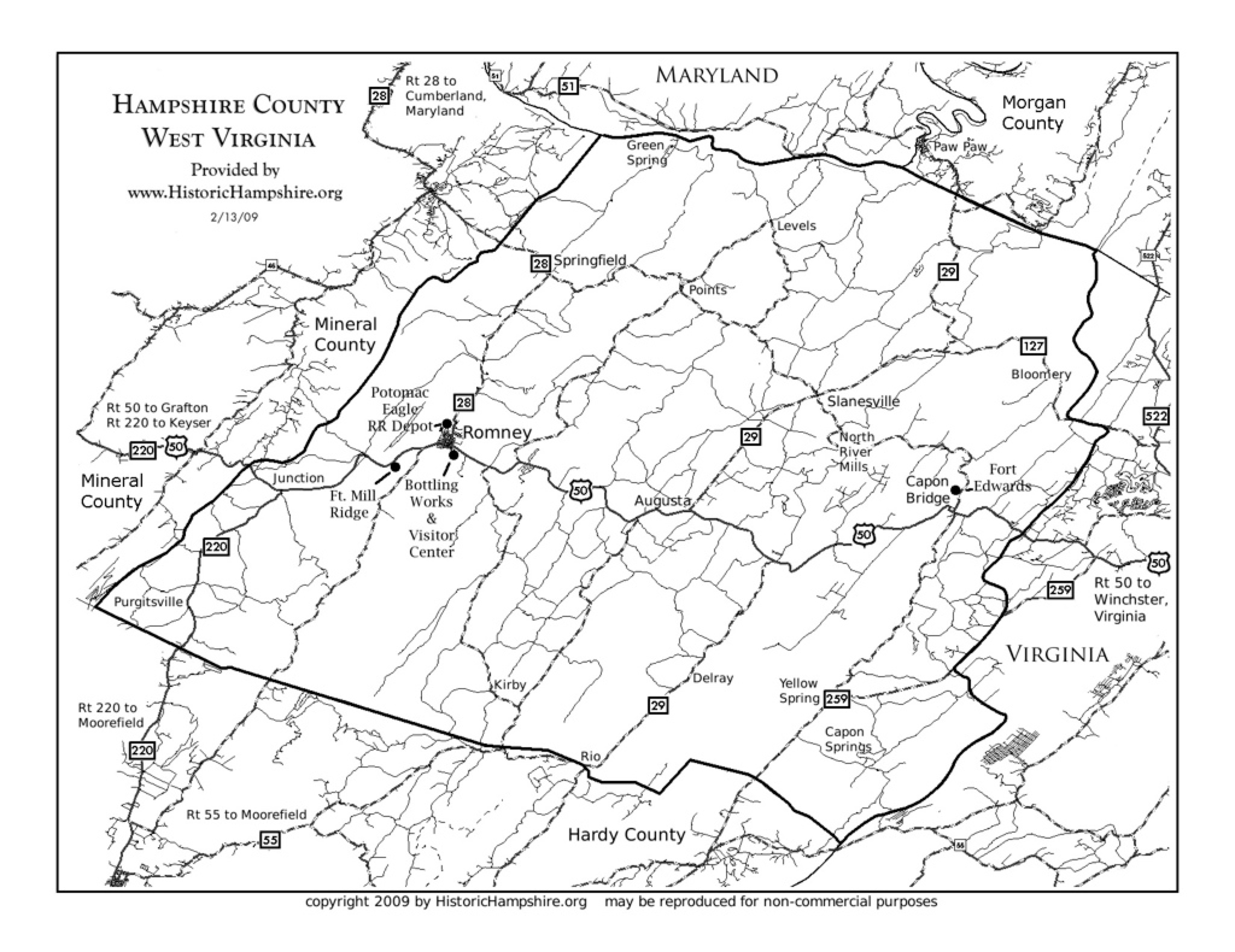
"Hampshire County is a county located in the U.S. state of West Virginia.
Its county seat is Romney, West Virginia's oldest town (1762). Hampshire
County was created by the Virginia General Assembly on December 13, 1753,
from parts of Frederick and Augusta counties (Virginia) and is the oldest county
in the state of West Virginia." Wikipedia Originally part of VIRGINIA,
"West Virginia became a state following the Wheeling Conventions, during the
American Civil War. The new state was admitted to the Union on June 20, 1863..."
• Hampshire County History, Department of Political Science, West Virginia University
• Historic Hampshire County, WEST VIRGINIA
• Hampshire County, West Virginia Settlement And Early Growth
• Timeline of Hampshire County History
• Hampshire County, West Virginia @ FamilySearch.org
• History of Hampshire County @ WVEncyclopedia.org
• Hampshire County Pedigree
• Posted at Hampshire County @ WVGenWeb@ USGenWeb
• Interactive map of Hampshire County boundary changes.
In 1603, when the first English settlers arrived at Jamestown, the Hampshire County area was hunting grounds for the
Shawnee, Mingo, Tuskarora, Wyandot (also called Huron), and Cherokee.
The area was successively known as follows:
• Lancaster County VIRGINIA was established in 1651 from Northumberland and York
counties.
• "Old" Rappannock County was founded 1656 from part of Lancaster County.
• Essex County was formed in 1692 from Rappahannock County.
• King and Queen County was established in 1691 from New Kent County
• King William County was formed in 1701.
• Spotsylvania County in 1721 was formed from Essex, King and Queen, and King
William counties.
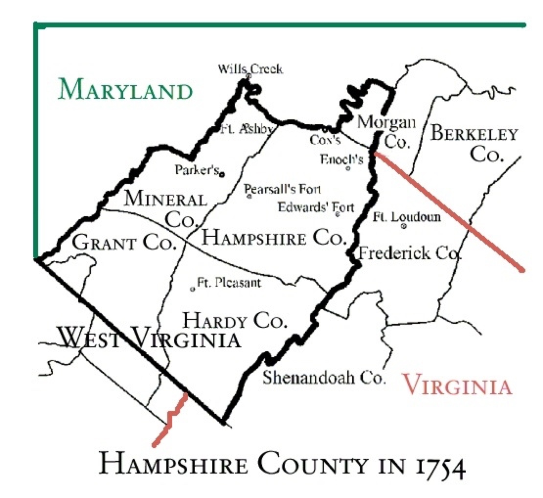
• In the mid 1720s, the area around the city of Romney, now the Hampshire County
seat, was initially settled by European hunters and traders.
• The area became Orange County in 1734 and
• Frederick County in 1738.
• Augusta County was formed in 1738 from Orange County, although county
government was not organized until 1745.
"all that portion of the Colony of Virginia which lay west of the Blue Ridge Mountains
was erected into a County which was named Augusta. In December of that year,
the
County Court was organized and held its first sitting. Prior to that time it had
become the refuge and abiding place of a strong body of Scotch-Irish immigrants.
The bounds of the new County were limited on the north by Fairfax's Northern
Neck Grant and the boundaries of Maryland and Pennsylvania to the westward of
Fairfax; on the east by the Blue Ridge Mountains; on the south by the Caroline
line. On the west it's territory embraced all the soil held by the British without limit
of extent."
• In 1744, Virginia officials purchased the Iroquois title of ownership to West Virginia in
• In 1748-49 the first sixteen Fairfax Grant lots on "Patterson Creek below (north of )
the Patterson Creek Manor" were sold.
• On December 13, 1753, Hampshire County was created by the Virginia General
Assembly from parts of Frederick and Augusta counties but was not actually organized
until 1757 because the area was not considered safe due to the outbreak of the French
and Indian War (1754–1763). The first meeting of the Hampshire County Court was
held in 1757, at Fort Pleasant, now Old Fields in Hardy County.
"Considering the needs of the South Branch region, the Assembly in 1754 made
provision for the formation of
the new county of Hampshire from the territory of Frederick and Augusta with
boundaries extending westward
to the "utmost parts of Virginia." The county was organized in 1757. The presiding
justice of the first county court
was Thomas Bryan Martin, a nephew of Lord Fairfax. Romney was established by law in 1762 (by Fairfax)."
(BOOK: History of West Virginia, old and new, in one volume, and West Virginia biography, in two additional
volumes (1923) by James Morton Callahan, page 54, Archive.org)
• In 1785 Hardy County was divided from Hampshire County.
• And In 1820 a portion of Hampshire County and Berkley County were used to create Morgan County,
• "During the American Civil War, the Hampshire Guards and Frontier Riflemen joined the Confederate Army. Although there
were no major battles in Hampshire County, Romney changed hands at least fifty-six times during the war. It was often a case
of one army evacuating the area allowing the opposing army to move into the town. This places Romney second behind
Winchester as the town that changed hands the most during the American Civil War. On June 11, 1861, [Romney] changed
hands twice in the same day." Wikipedia
• Finally, in 1862, Hampshire County split from VIRGINIA and placed in the newly formed WEST VIRGINIA; the new state was
admitted into the Union on June 20, 1863. "It was during the war that Virginia was split, and Hampshire County became part
of the new state of West Virginia. Hampshire's placement in the new state was a matter of Federal politics and did not reflect
the sentiments of the people of the county… Hampshire County raised thirteen Confederate companies for the war but only
one Union company." Historic Hampshire County, West Virginia
• Patterson Creek aka Patterson's Creek aka Pattersons Creek
• "Patterson Creek is a 51.2-mile-long (82.4 km) tributary of the North Branch Potomac River in West Virginia's Eastern
Panhandle, in the United States. It enters the North Branch east of Cumberland, Maryland, with its headwaters located in
Grant County, West Virginia. Patterson Creek is the watershed for two-thirds of Mineral County." (Wikipedia)
• "Patterson Creek is an unincorporated community in Mineral County, West Virginia, USA. It lies at the northeastern end of the
county, and is named for Patterson Creek which empties into the North Branch Potomac River here." (Wikipedia)
• Early Settlers of Patterson's Creek
• BOOK: Early Land Grants and Settlers Along Patterson Creek by Charles Morrison [excerpted and edited]
• "Land seems to have been lifted up in two ways, one a vertical movement which elevated large areas and formed plateaus,
but not mountains; the other, a horizontal movement which caused folds in the strata, and these folds, if large enough, are
ranges of mountains. In some eases these folds of earth-crust rose directly across the channel of the earlier bed of a river
which in spite of the steady upward movement, continued to cut its way across, forming a gap such as that cut by the Potomac
at Harpers Ferry, by the South Branch at Hanging Rocks, by Mill creek at Mechanicsburg, by Pattersons creek at
Greenland, by North Fork at Hopewell, by Tygart's river at Laurel Hill in Randolph and by Cheat at Brievy Mountain in Preston.
In these instances and in many others, the long and incessant struggle of the rivers has wrought a grandness and
picturesqueness of wild scenery too little appreciated in the earlier struggle for possession and the later reckless race for
riches." (BOOK: History of West Virginia, old and new, in one volume, and West Virginia biography, in two additional volumes
(1923) by James Morton Callahan, page 29 Archive.org)