WEST VIRGINIA Index: Hampshire History, PARKERs, PARKER Timeline, PARKER Map
↳ General History, Early Settlers, FAIRFAX Grants, Life and War
On this page: George PARKER on GENN's 1748 survey map of Patterson's Creek Settlement; Settling the Blue Ridge; Early Settlers Along Patterson Creek; Genn
Survey of Early Settlers on Patterson Creek; Wilmer L. KERNS' Early Settlers of Patterson's Creek - Map and List; Early Religious Migration, Additional Sources
Latest update: Monday, October 8, 2012
Learn more about our PARKERs in the Family Tree Database .
NOTE
Although WEST VIRGINIA is used on this webpage for convenience,
WEST VIRGINIA was part of VIRGINIA until June 20, 1863.
• George PARKER on GENN's 1748 survey map of Patterson's Creek Settlement
[editorial comment]
• Settling the Blue Ridge
The family tree of Noah HAMPTON [sourced below]
[excerpted and edited]
[quote]
The Colonial Virginian government had long encouraged the settlement of new people, concentrating on its eastern regions. In
1701 the Virginia Council passed Act: 1 "...for the better strengthening of the frontier and discovering the approach of an
enemy."
The first serious attempt to settle the Valley of Virginia began in 1716; Governor Spotswood led an expedition into VA [Knights
of the Golden Horseshoe Expedition], with the apparent hope that the publicity would encourage movement west. Little came
of it at the time. By 1730, after completing settlement on the upland country east of the Blue Ridge, some were giving serious
thought to the area west in the Great Valley. It should also be noted that Spotswood received a rather large land grant in the
new territory, which increased considerably in value with colonization.
[quote] CHAPTER V THE FIRST ADVANCE: Over two hundred years ago * the cosmopolitan Lieutenant-Governor
Alexander Spotswood of Virginia led an expedition which, by penetrating the fifty miles intervening between the frontier
and the peaks of the Blue Ridge, and descending beyond the valley of the Shenandoah, broke down the first barrier
which had checked the westward expansion of the English in America and began a conquest which made Virginia the
mother of an empire. (BOOK: "History of West Virginia, old and new, in one volume, and West Virginia biography,
in two additional volumes" by James Morton Callahan,1923, page 48, Archive.org) [end quote]
The work of those days was without bulldozers, chain saws, and other modern equipment. One can, without difficulty, conjure
up a picture of the back-breaking toil of clearing the land of trees, burning brush, building the first home, along with such other
structural dependencies as seemed necessary, in addition to raising crops for food.
One of the limitations of frontier society was the scarcity of hard money -- cash. Tobacco was for a time used as currency or a
medium of exchange. Trade was carried on by barter and the price of tobacco was the standard of valuation for merchandise.
The Legislature in imposing taxes, fines and penalties recognized tobacco as legal currency by ordering them to be collected
in tobacco.
The first settlers to a "wilderness" area, sometimes marked their property by cutting their initials in trees on the boundary of
what they considered to be their land, then they cut circles in the bark of the tree to kill it (girdled the tree). This method of
settling was an accepted practice in "wilderness" areas because there was in effect no other method for recording one's
ownership. Such a transaction would provide no documentation for one to follow, other than if there were a subsequent
transfer (sale) when recording of documents was available. Conceivably, a settler might make a deal with his neighbor to sell
land and there would be no recordation at this early date. Everyone in the neighborhood would be aware of the transaction
and boundaries involved (sometimes clarified by processioning), but not necessarily a recordation.
What were the motivations for migration? Why were these early settlers constantly pushing the border outward from
established settlements into the western wilderness. They were influenced by a variety of factors. One will find that the political
environment and economic conditions of the 1700s made it ripe for such a migration. These pioneers wanted freedom to live
and worship the way they believed, in some cases religious differences had grown into factional differences (particularity for
some of the Quaker families). Land policy was favorable and the government encouraged settlement through the sale of
cheap land. An expanding population in the eastern states (and subsequent high cost of land) was also a major factor.
The early methods of farming resulted in an economy and population that depended on acquiring new, fertile land to sustain
growth. Without rotation of crops or fertilizers, new land had to be cleared for cultivation because of the rapid exhaustion of
tillable land. Faced with less productive agricultural lands and the promise of new land, one can understand why they
migrated. Simply stated, the promise that drew many of these early frontier families was one of plentiful, cheap, fertile land.
One must remember that this was primarily an agrarian economy and society at the time. Maintenance of the family always
required more land. If the family had 500 acres and 5-10 children, it is easy to see that each child would inherit 50 to 100
acres. It is also easy to see that the next generation (second generation) would inherit only 5 to 20 acres each, thus the family
needed more land in order to sustain itself.
Early colonists also heard all manner of tales about the western frontier. They heard these accounts from land speculators
who were motivated by the need to encourage settlement into the area and thus profit financially from demand for their lands.
They also heard from adventurers and early explorers about fertile land for farming, virgin forests, and animal herds that made
hunting easy.
Upon arriving in a new area, Gristmills were among the first order of business for the early settlers and the roads leading to
them were among the most important. The only other road of equal importance was the road to the courthouse and town.
Usually, these two roads were the first to be improved. The gristmills allowed the settlers to turn their corn into cornmeal or
their wheat into flour. The settlers would soon have excess crops to sell in larger markets and needed access to those
markets.
The main route of migration from the east began in Philadelphia. It was called "The Great Wagon Road" and began in
Philadelphia as the Philadelphia Wagon Road, ran west through the middle of Pennsylvania. From Philadelphia (on today's
maps), it crosses Delaware Co., then Chester Co., Lancaster Co., York Co., and exits PA at the southwestern corner of Adams
Co. It continues into Washington Co., WV though Berkeley Co., through Frederick Co., Shenandorn Co., Rockingham Co.,
Stauton Co., Rockbridge Co., Botetourt Co. and then branches at Roanoke Co. on into the Carolinas. There is an excellent
map of the trail in Everton's Handybook for Genealogists, 9th edition.
The Great Wagon Road brings visions of large Conestoga Wagons (first built along that road in Conestoga, Pennsylvania)
pulled by large teams of oxen or horses. This was not such a road in the early days. It was initially more of a trail circa 1730
according to many reports.
The Valley was still Indian country when the first white settlers came. A treaty was still in effect, made in 1722 at Albany,
between the chiefs of the Five Nations and the governors of New York, Pennsylvania and Virginia. By this treaty the Iroquois
and their allies agreed to stay west of the Blue Ridge with the east side reserved for the whites. So the settlers in the Valley
were trespassers in terms of the Albany Treaty. In the 1730s it appears that no particular tribe was based in the northern
Valley, but rather it was a hunting ground visited periodically by hunters of several tribes. Nevertheless, the settlers had moved
west of the Treaty line.
[quote] The earliest permanent settlers in the eastern panhandle, however, entered from Pennsylvania by the
"Old Pack-horse Ford" (at Shepherdstown). By 1727 Morgan Morgan settled on Mill creek (in Berkeley county)
and Germans began a settlement which later grew into a village called New Mechlenberg (now Shepherdstown).
(BOOK: "History of West Virginia, old and new, in one volume, and West Virginia biography,
in two additional volumes" by James Morton Callahan,1923, page 49, Archive.org) [end quote]
Robert "King" Carter was Lord Fairfax' land agent in Virginia and he was also the senior member of Governor Gooch's
Council. He objected to Gooch's plan to grant away the Valley land claimed by Fairfax,* but the Lords Commissioners in
London, fearing the French, pressed Gooch to get on with it. Between 1728 and 1736 the Governor signed Orders in Council,
which granted 15 or more huge tracts of Valley land to various applicants.
*King Charles II of England in the middle 1600's had rewarded a prominent Scottish family with a grant of the "Northern Neck"
of Virginia. Thomas, sixth Lord Fairfax, Baron of Cameron in Scotland (subsequent heir to the grant), arrived at Williamsburg
in May 1735 to investigate his inheritance, only to find that the Colonial Government had issued settlement grants on his
property to Hite, McKay and others. Fairfax paid two visits to the home of Jost Hite on the Opequon in 1736 and 1737.
These produced no favorable results for him, so he settled himself on a 10,000-acre tract about five miles east of Hite, and
proceeded to have his land surveyed. George Washington, aged 16, was one of the surveyors and a favorite of Lord Fairfax.
In has been reported that in 1726, Morgan Morgan, founded the first permanent English settlement of record in West Virginia
on Mill Creek near the present site of Bunker Hill in Berkeley County. (TK Cartmell disputes this stating that Morgan bought his
land from Hite and it was part of the Van Meter Grant). Cecil O'Dell documents Morgan as arriving on the Opequon in 1730.
[quote] In 1730 and within a few years thereafter, other daring pioneers settled upon the Opequon, Back creek,
Tuscarora creek, Cacapon, and farther west on the South Branch. Among; those who founded homes along the
Potomac in what is now Jefferson and Berkeley counties were the Shepherds, Robert Harper (at Harper's Perry),
William Stroop, Thomas and William Forester, Van Swearinger, James Porman, Edward Lucas, Jacob Hite, Jacob
Lemon, Richard and Edward Mercer, Jacob Van Meter, Robert Stockton, Robert Buckles, John and Samuel Taylor
and John Wright. In 1736 an exploring party traced the Potomac to its source... In 1732 Joist (Yost) Hite and fifteen
other families cut their way through the wilderness from York, Pennsylvania, and crossing the Potomac two miles
above Harpers Ferry proceeded to the vicinity of Winchester and made settlements which exerted a great influence
upon the early neighboring settlements in the territory now included in West Virginia. (BOOK: "History of West Virginia,
old and new, in one volume, and West Virginia biography, in two additional volumes" by James Morton Callahan,
1923, page 51, Archive.org) [end quote]
It has been reported that Adam Miller settled in the Valley as early as 1726 or 1727. Cartmell disputes this also.
Cecil O'Dell estimates Morgan Bryan moving to the Potomac River (east of the Blue Ridge on Milltown Creek) in 1726 or
1727 ...."where he assigned (sold) 1303 acres to John Mills by March 5 1729/30 when Mills has a warrant issued by the
Proprietors Office."
Thus it appears, by almost everyone's research, that the first earnest settlement in the area was circa 1730. There may have
been a few earlier forays to explore the area, for instance, Issac Vanmeter had been there prior to 1730 to view the lands he
applied for in his Grant.
The Van Meters, [Berkeley County, West Virginia] John and his brother Isaac were Indian Traders who knew the country about
the Potomac and the Shenandoah as early as 1728. In 1730 John and Issac Van Meter applied to Lord Fairfax for land
grants in VA totaling 40,000 acres upon which to settle their families and friends. "The land applied for on June 17, 1730 ...
lying ... the fork of the Sherundo River & the River Opeckon in as many several tracts or dividends as shall be necessary" ......
Before the two years were up in which the Van Meters had to colonize the land granted, they had assigned their
Grant to Jost Hite and he in turn brought in Robert McKoy (McKay) as a partner. This transfer by the Van Meters to Hite
was on August 5, 1731. Then on Oct. 25, 1731 Hite & McKay received a grant for 100,000 acres on the west side of the Blue
Ridge under the same conditions.
When Hite first arrived on what he believed to be his land in VA (circa 1730/31), he found blazed trees, planted
monuments and other marks that indicated to him that someone had already been there. He soon found out from
immigrants coming in, who had made these marks. The people coming in carried with them deeds from the Van Meters. Hite
had known of the Van Meters from New Jersey. Hite quickly realized that problems lay ahead, especially since the Vanmeter
grant appeared to predate his grant and thus was senior. It would appear Hite saw a solution to the problem and an
opportunity. Hite quickly arranged to buy the Vanmeters Grant (of June 17th, 1730) and it was assigned to Hite in 1731.
Hite appears to have sold out in PA and moved to VA circa 1730-31. In 1731, Hite first settled in the area of what is now
Shepherdstown, West Virginia, naming it New Mechlenburg. The 40,000 acres granted were located in Spotsylvania, VA -
soon to be the new County of Orange in VA, which was created from Spotsylvania County in 1734. The trip from
Pennsylvania to Virginia in 1731 was slow. It has been reported that a passable road over the rough terrain had to be
cleared in places for the wagon train as they went. The Potomac River was crossed a few miles above the mouth of the
Shenandoah.
[end quote]
• Early Settlers Along Patterson Creek
BOOK: Early Land Grants and Settlers Along Patterson Creek [sourced below]
[excerpted and edited]
[quote]
Before any Europeans discovered the fertile flood plain of Patterson Creek, Indians had followed its lazy meanders to or from
Cohongorooton, or Potomac, and traced the unusual twin mountain gaps that both link and separate the New Creek and
Patterson Creek valleys. Between the creeks stand Knobly and New Creek mountains, guarding the main range of the
Alleghenies, sometimes known as Allegheny Mountain or Allegheny Front. This was all a consequence of the earth's long-ago
geological upheaval that created the mountains and valleys runnings generally from southwest to northeast between the Blue
Ridge and the Alleghenies. These ridges and valleys extend from the James River in the south to the Potomac in the north,
and in a less defined way to and beyond the Susquehanna.
The main road from Petersburg on the Potomac's South Branch along Lunice Creek and Pattersons Creek follows the route
of what was undoubtedly an old Indian road. Along the way the site of an ancient Indian fort was discovered some years ago,
and with it the artifacts of tribal life and warfare.
Patterson Creek itself originates on the northern slope of a low divide about one and one-half miles north of Lahmansville, in
Grant County. Several small runs combine near the community and are joined by others flowing from the hollows on the
western slope on Patterson Creek Mountain. Their courses can be readily visualized between the knobs that characterize this
part of the ridge.
By the meanders of the river, Patterson Creek joins the Potomac about thirteen miles below the mouth of Wills Creek, which is
at the site of old Fort Cumberland. The origin of the name is uncertain. Early maps of the upper Potomac show the name as
Pattisons or Patersons. These maps were based on a survey of the Potomac made in 1736 by Benjamin Winslow, William
Mayo, and others, on behalf of the Colony of Virginia and Thomas 6th Lord Fairfax. They are the first accurate maps of the
region.
Hamill Kenny, in West Virginia Place Names, associates the name of the stream with that of a person or family. Whatever the
origin, it must have been applied to the Creek before any permanent settlers arrived and possibly even before 1736. The
name Patterson does not appear in any official record for Hampshire County, except as a place name, until near the end of
the century, or about 1790. On the other hand, the family name Batson occurs in the census for both 1782 and 1784. Bateson,
too, is a family name that is associated with the Potomac's North Branch in western Maryland.
Although the official name of the stream is Patterson Creek, it is usually referred to locally as Pattersons Creek.
[end quote]
BOOK: "History of West Virginia, old and new, in one volume, and West Virginia biography, in two additional volumes" (sourced
below)
[excerpted and edited]
[quote, page 53]
In 1735 the first settlement in the valley of the South Branch was made in what is now Hampshire county by four families
named Cobun, Howard, Walker and Rutledge. A year afterwards Isaac Van Meter, Peter Casey, the Pancakes,
Foremans and others reared homes further up the South Branch — some of them located within what is now Hardy county.
When Mr. Van Metre returned to New York he advised his sons, that if they ever migrated to Virginia, to secure a part of the
South Branch bottom. He described it as "The Trough," and the finest body of land he had ever seen. One of his sons, Isaac
VanMetre, who was about to migrate, took his father's advice, and about the year 1736 or 1737, settled in Virginia. Mr.
VanMetre returned to New Jersey shortly afterward, and in 1740 came back, only to find other settlers on his place. He
went back to New Jersey again, and in 1744 returned with his family to make a permanent settlement. In the meantime a large
number had settled in the neighborhood, and already much progress could be noted.
By 1748 there were about 200 people along the entire course of the stream [South Branch].
• [The Moravian Diaries of Travels Through Virginia (1747 - 1749) offer excellent vision and insight
into the lives of Early Settlers in Hampshire County.]
• "Moravian missionaries, who preceded Genn's surveyors by nearly a year, mentioned many people, German
and English, who lived on Batesons Creek.Amongst them, in addition to Solomon Hedge, were Abraham
and William Degart, Oliver Creamer,14 and a man by the name of Kasselman. They described the people as
being religious, but uncertain about the Moravian beliefs. When one of the itinerants refused to marry a man
who was described as the son of an Englishman Solomon Hedges threatened to put him in the nearest prison.
That seemed not to happen and Hedges signed their passports and directed them over the mountain to the
South Branch, probably by the same road taken by Genn and his surveyors later. (BOOK: Early Land Grants
and Settlers Along Patterson Creek [sourced below])
• "By 1748, according to a Moravian missionary to the region of the South Branch Potomac and Patterson
Creek, there were so many Germans along those streams ‘'that in order to reach the people a minister
should be fluent in both German and English.’' In 1762, about 30 percent of the population of Jefferson and
Berkeley counties was German, and the centers of the German population were Shepherdstown and
Martinsburg." (Germans @ West Virginia Encyclopedia)
The expansion of settlements was influenced by conditions resulting from the great land grants owned by Lord Fairfax,
[end quote]
• Genn Survey of Early Settlers on Patterson Creek
The Frontier Surveyor [sourced below]
[excerpted and edited]
[quote]
Even before the ownership of the unappropriated lands in the Northern Neck had been definitely determined, Lord Fairfax
had made known his desire to open, to settle, and to develop them. As the first surveying party sent out for these purposes
had experienced no mishaps or unusual adventures, young [George] Washington was allowed to accompany the party going
beyond the mountains in the spring of 1748. This party was in the charge of James Genn, the county surveyor of
Prince William County and a man of many adventures in the wilderness. (The Genn Family of Canada) Accompanied by
young Washington, Rodmen, Chainmen, and other attendants, Genn set out March 11. Going by way of Ashby's Gap and
Greenway Court he made his first important stop on the South Branch of the Potomac where that stream intersected the
"Fairfax Boundary" which had been determined two years previously. Washington kept a diary of his experiences and
adventures.
[end quote]
• Wilmer L. KERNS' Early Settlers of Patterson's Creek: Map and List
[sourced below]
[excerpted and edited]
[quote]
Wilmer L. KERNS, scholar, historian and author, compiled a LIST of the early settlers of lower Patterson's Creek when a
survey map was made by James Genn in early 1748... The value of this map and material is that it showed not only who was
living on the land before or at the time of a survey, but it reveals where the cabins were located prior to the issuance of Fairfax
In addition, KERNS identified the "The Lost Map" -- the survey map of Patterson's Creek Settlement by James Genn in early
1748 made prior to Fairfax issuing grants in 1748-1749. KERNS wrote: "By the way, the Patterson's Creek Settlement is not
the same as the Manor. Morrison published the map of the manor and sought the other map for his entire later life. I wrote to
him several months before he died in Pennsylvania, and told him that I have the map and that we would get together soon. He
answered me, but he died before we could arrange a time to meet."
[end quote]
[KERNS contributed his discoveries of the "Early Settlers of Patterson's Creek"
MAP
and
LIST
to Mineral County, WVGenWeb. Patti McDonald of Mineral County, WVGenWeb notes the history of the "Early Settlers of
Patterson's Creek" Map and List. KERNS included the List of Early Settlers of Patterson's Creek in several places. We have
tried to include in {curly brackets} additional information found in the different version of his List. Of particular interest to the
ancestors of George PARKER of Patterson's Creek is the description and the location of his land.]
From: "Wilmer L. Kerns"
Subject: WVHAMPSH-L First Settlers of Lower Patterson's Creek Settlement
Date: Sun, 10 Dec 2000 17:02:07 -0500
[Also posted at The Tom and Brenda Parry Family.]
[quote]
{Lower Patterson's Creek Valley attracted settlers as early as 1735. Some of the first pioneers expected to establish a western
trading post with the Indians, and to later settle the Ohio Valley. By 1735, conflict with Indians was irreconcilable, and the
French and Indian War was fought on these lands. Turnover rate in the new settlement was high during the first three
decades, 1735 - 1765, due to disease and death, dissatisfaction with the locale, and problems with the Indian population to the
west. Moravian missionaries visited the settlement in 1747, and Bishop Asbury visited Patterson's Creek Valley in 1783. By
1747, about 22 settler-families had staked out land and built cabins between Headsville and the mouth of the Creek at the
Potomac River. The lots ranged in size between 167 and 399 acres per farm. In 1748, Lord Fairfax assigned surveyor James
Genn of Prince William County to survey the lots and to develop a survey map of the settlement, to be followed by the
issuance of individual grants. Not all of the first families remained in the settlement, and grants were made to replacement
settlers.} [?]
Here is a list of the early settlers of lower Patterson's Creek when a survey map was made by James Genn in early 1748. This
map has not been published nor quoted from as a primary source. Some of the first settlers were no longer there when Fairfax
grants were later issued. I have done additional tracing of subsequent lot owners, not presented here. (Note: George
Washington was not the surveyor of the lower Patterson's Creek settlement.)
When James Genn arrived to survey these lots in early 1748, 17 log cabins were already built, proven by the survey map. No
one knows how long the settlers had been there, but rule-of-thumb says 10-12 years for the earliest ones. The Editor of the
West Virginia Advocate and I spent one summer (about 1990) making on-site inspections and photographs for all the lots. We
found only 3 present-day houses located on the same sites as the original cabins. We had planned on publishing our findings,
but the project was not completed. I have a copy of a 1749 road petition from the Patterson's Creek settlers to the court in
Winchester. This is a valuable list of names, some of who are not found elsewhere in land records. I created a graphic display
of the early history of the Patterson's Creek settlement (not the Manor). I want to donate the display of survey map and
historical documents and narrative to either Mineral County or Hampshire, provided they are interested.
Here is a sketch on the earliest settlers:
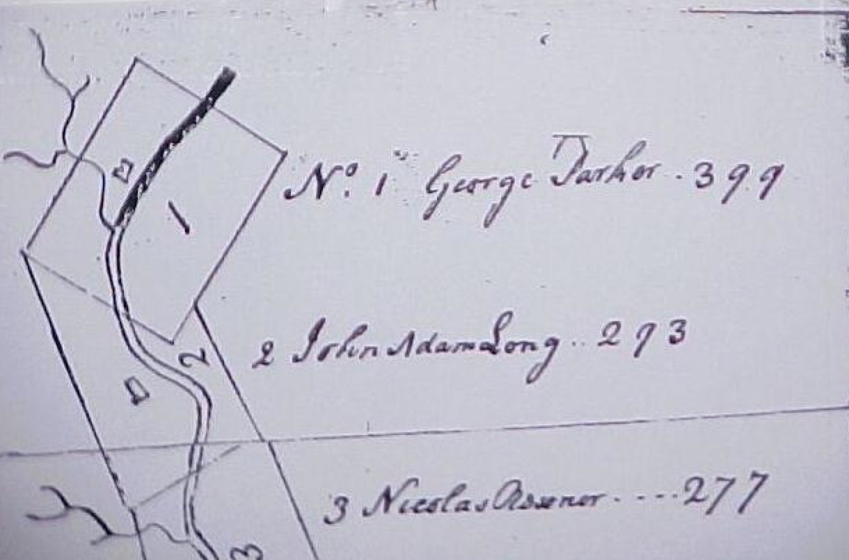
#1 George Parker's house was located on the east side of Patterson's Creek, near a small and unnamed stream. The
major road between Winchester and Patterson's Creek came directly to Parker's farm {passed through Parker's farm}
George Washington referred to Parker's farm as a "plantation." Fairfax issued a grant to Parker on Oct. 25, 1748. Lot
#1 adjoined the Patterson Creek Manor {not to be confused with Patterson's Creek settlement} The community of
Headsville, Mineral County, WV is located on Parker's former land. Parker died in 1757 and his oldest son Benjamin
(1722-1804) inherited his estate of 399 acres.
#2 John Adam Long was living on this 293-acre farm when Genn made the survey. Fairfax issued the grant on Oct. 2, 1748.
Long was scalped by Indians when he was 55 years old. His son Christian Long sold the farm to John Reno in 1761.
[The ground Fairview rests on was part of John Adam Long's 293 acre grant of October 2, 1748, known as Lot 2.
Christian Long conveyed the land, a part of Hampshire County after it's formation in 1754, to John Reno on March
25, 1761. By 1762, George Corn owned the 299 acre Lot 2…" (National Register of Historic Places, National Park
Service, United States Department of the Interior, NPS Form 10-900 dated 21 October 1992,
West Virginia Division of Culture and History)
[• Benjamin PARKER (James PARKER and Rebecca WOLFE) married
Elizabeth "Eliza" Jane LONG (David LONG, grandson of John Adam LONG, and Elizabeth UNKNOWN LONG)
• Margaret PARKER (James PARKER and Rebecca WOLFE) married
Joseph LONG (David LONG and Elizabeth UNKNOWN LONG).]
#3 Nicholas Reasoner received a Fairfax grant for this 277-acre farm on Oct. 23, 1748. His house was located on the east
side of the Creek. The land stayed with the Reasoner family until the early 1800s.
#4 John Rutand (sometimes spelled Ratan) was issued a Fairfax grant on Oct. 25, 1748. 354 acres. Rutand may have been
killed by Indians. Abraham Johnson bought Rutand's land and built a mill on it, known today as Reese's Mill.
#5 Abraham Johnson came to Patterson's Creek from New Jersey. Johnson was a trader with Indians and an official in the
Ohio Company. His lot was the best one in this settlement, based on running streams and fertile land as well as a great site
for protection from Indians. Mr. and Mrs. John M. Kykendall (descendants of Johnson) live in a house that is in the same
location as Johnson's original cabin. 309 acres.
Lot #X was located between Lots #5 and #6. This choice lot was created for a close friend of Lord Fairfax, John Greenfield.
The plat shows 200 acres with no dwelling house when the survey was made. Greenfield was a County Lt. in the Frederick
County militia, with residence in Winchester. He came from Waddington, Scotland. Died in 1768 and left no children. His wife
Mary and brother William Greenfield in Scotland were the heirs. Greenfield owned so much land that his executor could not
identify and locate all of his properties. There are some interesting stories about some of his lands in Little Cacapon (executor
didn't find land later claimed by Largents).
#6 David Thompson Sr. was the first occupant of this lot. Fairfax issued the grant on June 1, 1749. Rectangular lot of 312
acres. Jacob Reasoner bought the farm in 1790.
#7 William Teagard (born on March 15, 1720) was the first occupant of this lot but moved before a grant was issued. William's
older brother, Abraham Teagarden (1719-1783) lived also at Patterson Creek. Abraham married Mary Parker. It is believed
that Christopher Bean received a Fairfax grant on June 2, 1749, but died shortly thereafter. Bean was in the process of selling
the 321-acre farm to Robert Gregg, but didn't complete the process and the land was forfeited back to Lord Fairfax. In 1773,
Col. Elias Poston surveyed the land for John Colson.
#8 Power Hazle built a house on the west side of Patterson's Creek. Hazle's Run was named for him. 320 acres.
#9 This 200-acre lot was vacant when surveyed by Genn and not granted to anyone in 1748-1749. Further research
in the Fairfax grants should help identify the first owner.
#10 Nicholas Crist settled on this lot of 167 acres. A Fairfax grant was issued on June 6, 1749. Okey Johnson
bought the land in 1774.
#11 Joseph Hamblin first settled on this lot of 289 acres. Fairfax issued a grant on June 7, 1749 to Hamblin (possibly
Hamilton?). Hamblin sold 50 acres to Henry Bagley in 1761. Hamblin wanted to give land to his sons but they had migrated far
into the wilderness and could not be located. In 1769, he gave his land to Job Pearsall, who died in 1770. In 1771, Fairfax
awarded the land to John Pearsall, eldest son of Job.
#12 This lot was occupied by David York when Genn surveyed the land. York sold the 312-acre farm to John Parker,
who received a Fairfax grant on June 9, 1749. Parker died in 1760, and his widow Elizabeth married second to
#13 Matthew Rogers Sr. built a house on the east side of the Creek, and received a Fairfax grant for 379 acres on June 10,
1749. George's Road is located on this lot. Rogers died before 1753 and his son Matthew Rogers Jr. inherited the land.
Matthew's (Sr) widow married a Mr. Lindsey. Peter Beaver came in 1760 (Beaver's Run named for him).
#14 Jacob Good received a Fairfax grant on June 11, 1749 for 394 acres. His house on the east side of the Creek was built
prior to Genn's survey. Good's will was probated in 1780, which named his wife Susannah and children Peter, Abraham, and
Isaac Good.
#15 Walter Casper (Casper Walter?) was living on this 238-acre lot when the survey was made. On June 11, 1749, Fairfax
issued a grant to Joseph Walter.
#16 Charles Keller first lived on this 300-acre lot. Keller died or was killed by Indians and Fairfax issued a grant to Charles'
son John Keller June 1, 1779. A house was shown in the center of the plat, on the east side of the Creek. In 1755, Fort Ashby
was built on this same site as a protection from the Indians. In 1787, the town of Frankfort was built on lot #16 (now known as
Fort Ashby, WV). The old fort has been restored on it's original site.
#17 A McCracken family first lived on this site, but they were not there when the survey was made in 1748. The family was
killed by Indians. Philip Martin was the first Fairfax grantee for this lot.
#18 A widow, Catherine Bennett, lived on this lot when the survey was made in 1748. Possibly her husband had been killed
by Indians. This 306-acre farm has a nice stream running across the property. The house was located on the west side of
Patterson's Creek because a mountain was on the east side. The house was located very close to the bank of the Creek.
#19 A house was located on this lot, but the name of owner was torn off the survey map.
#20 No house was on this lot when the survey was made. This was perhaps the least desirable lot, because the eastern half
was a mountain and there was very little fertile land on the west side.
#21 Joseph Robinson received a Fairfax grant on June 11, 1749 for 332 acres. In 1773 Robinson sold part of the lot to
William Campbell who held it for 13 years before selling to Balson Shelhorn. Robinson's original log cabin survived until 1979,
when it was dismantled and sold. Jerry Sears, current owner, built a house on the original site.
This would be a great site for archaeological research.
#22 Philip Martin, "County of Kent" received a Fairfax grant on June 11, 1749 for 283 acres. Martin was a nephew of Lord
Fairfax. Martin leased the land to John Hartley in 1769. This was a choice lot because it bordered the Potomac River, but was
known for having absentee landlords. The B&O Railroad was built across this lot. During the 1840s, David Gibson bought lots
20-22 and built a mansion house on #22. It is a beautiful house.
This information was shared because it required no further research on my part to post on this website. I am not actively
researching this subject at the present time, but may resume at a later date.
Wilmer L. Kerns
addendum
From: "Wilmer L. Kerns"
Subject: WVHAMPSH-L rare information on early Patterson's Creek Settlement
Date: Sat, 26 Jul 2003 16:18:55 -0400
...
This information is being shared to help those who have early ancestors in the Patterson Creek Settlement. Please note that
this is NOT the Patterson's Creek Manor, which started at about Headsville and ran upstream into Grant County, WV. Charles
Morrison published a booklet on that Manor. This one is THE Patterson's Creek Settlement, about which little nor has nothing
been published.
All that I ask is that no one copy this verbatim and publish it. Some of this material will probably be placed in an appendix to my
Hampshire County history, whenever that is published. The value of this map and material is that it showed not only who was
living on the land before or at the time of a survey, but it reveals where the cabins were located prior to the issuance of Fairfax
grants.
[end quote]
Additional Resources:
• Malone & Hilleary Family History: "List of persons to whom lots were granted on Pattersons Creek, from the first
survey made by George Washington and James Genn, March, 1748."
• SANDUSKY-L Archives: Archiver > SANDUSKY > 2000-12 > 0976518340
• Early Religious Migration
BOOK: "History of West Virginia, old and new, in one volume, and West Virginia biography, in two additional volumes" (sourced
below)
[excerpted and edited]
[quote]
page 53
The majority of the first immigrants were principally from Pennsylvania, composed of native Germans or German
extraction. A number, however, were direct from Germany, and several from Maryland, New Jersey and New York. These
immigrants brought with them the religion, customs and habits of their ancestors. They constituted three religious sects, viz. :
Lutherans, Menonists and Calvanists, with a few Tunkers, and were very strict in their worship.
page 261
The Baptist Church
Members' of the Baptist denomination early found homes in the mountains of western Virginia, although the colonial
government regarded that sect as among the most obnoxious of the dissenters from the Established Church. Many Baptist
ministers refused to regard the Toleration Act, which was in force in Virginia. When they attempted to preach in the East they
were set upon by ruffians, who pelted them with such missiles as stones, live snakes, or hornets' nests; or, who beat them, or
threw them into the water. If they did not heed these warnings to move on, they were arrested and confined in damp jails
through the bars of which they continued to preach. One Baptist historian says that many of these preachers brought much of
their suffering upon themselves, that they were frequently noisy and spectacular, and attracted attention by the strangeness of
their actions.
The Baptists that migrated into the mountains of western Virginia found peace. In that region there were no ministers of the
Established Church to complain of their aggressiveness; and the colonial government ignored their refusal to conform,
because every new settler, regardless of his religion, was a useful defender for the western frontier of Virginia.
About 1742 fourteen Baptist families migrated from New Jersey and settled in the vicinity of Gerardstown in Berkeley county.
They stayed there until about 1755 when the threatening dangers of the French and Indian war drove them to take refuge
east of the Blue Ridge mountains. After the war was over they returned, and in 1770 organized a Baptist church at Mill Creek.
Probably the first Baptist minister, in what is now West Virginia, was the Rev. Shubal Stearnes, who came into this region as a
missionary to the Indians. He started from New England, in 1754, with a few of his followers. At Opequon in Berkeley county
he halted. Here he found a Baptist church already established and under the care of S. Hinton. At this place he met Daniel
Marshall, a Baptist missionary, who had just returned from a visit to the Indians. They, together, moved to Cacapon,
Hampshire county, where, about 1755 they established the first Baptist church in the County. They moved soon after to
North Carolina. In 1787, under the pastorate of B. Stone, a Baptist church was organized on North river in Hampshire
county. In 1790, Stone organized his second church in Hampshire county on Crooked run. Dr. Munroe, who combined the
practice of medicine with that of preaching, early organized a Baptist church on Patterson's creek in Mineral county.
The Presbyterian Church
Among the early settlers of western Virginia were many Presbyterians. In 1738 the Synod of Philadelphia asked of Governor
Gooch permission for Presbyterians to settle in there. Governor Gooch readily granted the request, stipulating that the settlers
must conform to the Toleration Act in force in Virginia. There is no evidence that any meeting places were appointed for
Presbyterians, but it is probable that members of that denomination were already living in the valley when the governor gave
his consent for their settlement farther west. William Hoge established the Opeckon church in the lower part of the
Shenandoah valley in 1735. Other Presbyterian churches in that region soon came into existence through the efforts of
missionaries and preachers from the Synod of Philadelphia who frequently visited the Presbyterian families in the valley of
Virginia. In 1782 Hardy county had a Presbyterian minister who had preached near Moorefield for five years. In 1782 he
accepted a call from Shepherdstown. In 1792 Mt. Bethel at "Three Churches" on Branch mountain, and the Presbyterian
church at Romney were organized in Hampshire county. In 1794, when the Winchester Presbytery was formed, the
Reverend John Lyle was minister for the congregations of Frankfort, Romney, and Springfield. Previous to 1833 all
Presbyterian churches in Hampshire county were in the Mt. Bethel organization. In 1833, Mr. Foote was authorized to
establish separate organizations at Romney, Mount Bethel, North River, and Patterson's Creek.
[end quote]
• Moravian Diaries of Travels Through Virginia
• Sources
• The family tree of Noah HAMPTON at "John Hampton of Scotland & NJ" by Karl Hampton, posted at Genealogy.com
• BOOK: Early Land Grants and Settlers Along Patterson Creek by Charles Morrison, West Virginia History , A copyrighted
publication of West Virginia Archives and History, Volume 40, Number 2 (Winter 1979), pp. 164-99
• The Frontier Surveyor: Charles H. Ambler, George Washington and the West @ Archiving Early America
• Wilmer L. KERNS' Early Settlers of Patterson's Creek: Map and List @ Mineral County, WVGenWeb. Patti McDonald of
• BOOK: "History of West Virginia, old and new, in one volume, and West Virginia biography, in two additional volumes" by
James Morton Callahan, 1923, Archive.org