WEST VIRGINIA Index: Hampshire History, PARKERs, PARKER Timeline, PARKER Map
↳ General History, Early Settlers, FAIRFAX Grants, Life and War
On this page: French Indian War, American Revolutionary War, American Civil War
Latest update: Monday, October 22, 2012
Learn more about our PARKERs in the Family Tree Database .
NOTE
Although WEST VIRGINIA is used on this webpage for convenience,
WEST VIRGINIA was part of VIRGINIA until June 20, 1863.
[editorial comment]
"The Valley was still Indian country when the first white settlers came. A treaty was still in effect, made in 1722 at Albany,
between the chiefs of the Five Nations and the governors of New York, Pennsylvania and Virginia. By this treaty the Iroquois
and their allies agreed to stay west of the Blue Ridge with the east side reserved for the whites. So the settlers in the Valley
were trespassers in terms of the Albany Treaty. In the 1730s it appears that no particular tribe was based in the northern
Valley, but rather it was a hunting ground visited periodically by hunters of several tribes. Nevertheless, the settlers had
moved west of the Treaty line. (The family tree of Noah HAMPTON at "John Hampton of Scotland & NJ" by Karl Hampton,
posted at Genealogy.com.)
"Lower Patterson's Creek Valley attracted settlers as early as 1735. Some of the first pioneers expected to establish a western
trading post with the Indians, and to later settle the Ohio Valley. By 1735, conflict with Indians was irreconcilable, and the
French and Indian War was fought on these lands. Turnover rate in the new settlement was high during the first three
decades, 1735 - 1765, due to disease and death, dissatisfaction with the locale, and problems with the Indian population to the
west. Moravian missionaries visited the settlement in 1747, and Bishop Asbury visited Patterson's Creek Valley in 1783. By
1747, about 22 settler-families had staked out land and built cabins between Headsville and the mouth of the Creek
at the Potomac River. "
• 1754 - 1763: French Indian War
• "The French and Indian War was the first of several conflicts to disrupt life in Hampshire County. In the mid-1750s, Indians
(mostly Shawnee), encouraged by the French, attacked county settlements. Settlers either sought safety in nearby
fortifications, including Fort Pearsall, Fort Cox (near the mouth of the Little Cacapon), Fort Capon (near Forks-of-Cacapon),
and Fort Edwards (near present Capon Bridge), or fled eastward to the Shenandoah Valley. By the late 1750s, the colonial
army had secured the county’s settlement areas." (Hampshire County @ The West Virginia Encyclopedia)
• BOOK: Early Land Grants and Settlers Along Patterson Creek by Charles Morrison, West Virginia History
A copyrighted publication of West Virginia Archives and History, Volume 40, Number 2 (Winter 1979), pp. 164-99
[quote]
The year 1754 marked the commencement of hostilities between the French and the British over the control of the trans-
Allegheny country [The French Indian War, 1754 to 1763]. The French sought to establish a line of fortifications and
communication between Canada and Louisiana; the English, particularly those with interest in Virginia, wanted no such
infringement on their claims. By its earliest charter the colony was to extend west and northwest to the farthest sea.
Patterson Creeks unique chapter in history was made during this struggle. [George] Washington's diaries and letters
provide the most authentic source of information on events during these tragic years along the frontier. His entries were
sometimes based on reports that he was unable to verify, but he sensed the terror of the settlers and felt the despair of a
military man who is helpless to avert the cruelties of war from being inflicted on a civilian population.
By 1754 [Washington] had tasted defeat at Fort Necessity and the following year he had witnessed the ignominous [sic] rout of
Braddock's force along the Monongahela. That had opened Virginia's northwest frontier to the savage attacks from along the
Ohio.
The settlements along Pattersons Creek were particularly vulnerable. Fort Cumberland, at the confluence of Wills Creek
and the Potomac, could readily be avoided by the war parties, and by way of the passes and gaps across and through New
Creek and Knobly mountains the Indians could range up and down the Valley almost at will.
Although he was only twenty-three, Washington was appointed commander of the Virginia Regiment, which had been
organized to defend the frontier. The young colonel planned a line of forts extending from Fort Cumberland, in Maryland,
southward to the North Carolina border. The two northernmost forts were along Pattersons Creek, which in his list he
designated as Fort at Ashby's and Fort at Cocke's. These he judged to be twenty miles "distance from each other."
Washington considered Reasner's plantation, which was on Lot. No. 3, as a possible site for the defensive fort [but] he later
ordered [the fort] built at [George] Parker's, Lot. No. 1. [Although Parker's Lot No.1] was designated by Washington as the
site of a defensive fort to be garrisoned by Captain William Cocke's company of the Virginia Regiment... the fort may have
been built about one and one-quarter miles to the south on a hill on the east side of the Creek. This would have placed it
within Lot No. 12 of the Patterson Creek Manor. [Fort Cocke] [North American Forts]
From Pearsall's fort, near Romney, he wrote to Captain William Cocke, on October 23, 1755: "You are hereby Ordered to
remove with your Company from the place where you are now Quartered, to the Plantation of Nicholas Reasmer, in order
to . . . protect the inhabitants, by sending out frequent Scouting Parties." On the same day he wrote to his friend, George
William Fairfax, "We arrived here today, where I met Captains Cocks and Ashby, whom I have appointed to remain on
Pattersons Creek; the one at Nicholas Reasmers, the other at Seller's in order to protect the Inhabitants"
Three days later, from Fort Cumberland, he worte [sic] to Lieutenant Bacon of the Maryland Independent Company, "You are
to proceed to George Parkers Plantation, where you will meet with Captain William Cocks and his Company of Rangers, who
are ordered to erect a Work of Defense at the said place." It was to be a quadrangular fort of ninety feet, with bastions.
Another fort of the same dimensions was "to be built by Captain Ashby's Company, at the Plantation of Charles Sellers, or the
late McCrackin . . ." whichever was judged to be the most convenient.
Later on, he wrote to Governor Dinwiddie of a small fort "which we have built at the mouth of Patterson's Creek,
containing an officer and thirty men guarding stores. This had been attacked "smartly by French and Indians . . . and
were warmly received, upon which they retired." This small fort has been called Fort Sellars by some writers; more likely Fort
Sellars is an earlier name for the Fort at Ashby's. Nor was the small fort the one Washington referred to earlier as the fort on
"the Hill at the mouth of Patterson's Creek."
[[Three Fort PARKERs
• "In the early colonial days when this was the frontier, there was a strong-house across the North River
on Thomas Parker's 237 acre land grant. During the French and Indian War the area of the North River
Valley was attacked on at least two separate occasions. In the first documented attack, Sarah Gibbons,
daughter of James Gibbons whose home was on the other side of the Parker grant, was carried off by the
Indians. Eight or nine years later Sarah escaped and returned to her family."
(A Brief Look at North River
Mills, West Virginia by Stephanie L. Bailes and Charles C. Hall, posted at HistoricHampshire.org)
• Fort Cocke was first known as Fort “G. Parker,” but it later took the name of Captain William COCKE of the Virginia
Rangers.]]
[[Fort FORMAN
"Fort Forman (also spelled Furman or Foreman) was a stockade fort erected by Captain William Foreman at the
beginning of the French and Indian War situated three miles north of Romney on the South Branch Potomac River
near Vance on West Virginia Route 28. Fort Furman was in use from its construction in 1755 until 1764." (Wikipedia)
William FORMAN married Catherine PARKER, daughter of pioneer John PARKER; Captain FORMAN was killed
during the Revolutionary War.]]
Beyond this display of optimism in his report to the Govenor [sic], the young Commander was well aware of the plight of the
settlers he was supposed to protect. On his way from Pearsall's (Romney) to Fort Cumberland, on October 24 or 25, [1755]
he had seen the terrible consequences of an Indian raid. Beyond the cruel treatment of individuals, he sensed the havoc of
war in its effect on the land. Farms were deserted, houses burned, fields overrun, livestock wandering about, and the harvest
was being neglected. He assigned soldiers to guard those remaining farmers who were willing to go out and tend their fields
and livestock. With it all he was acutely conscious of the inadequacy of his own military forces.
By spring, 1756, the enemy had almost overrun the valleys to the west of North Mountain; the frontier was abandoned and its
forts evacuated or isolated. From his fort on Pattersons Creek, Captain Ashby reported that Indians had demanded the
surrender of the stockade, but that he had parleyed with them and they had departed without firing a gun. Later the same day
these Indians attacked the fort at the mouth of the Creek.
As the summer drew on, Washington's frustration mounted. Intransigence on the part of the civil government, recruiting and
disciplinary problems, deficiencies in supplies and ammunition, all contributed to the lack of protection he was able to provide
for the inhabitants that remained. Their lowland farms and settlements were the fabric of that pioneer society, but in the years
following Braddock's defeat they were in the midst of a land that was stricken by terror, tragedy, and desolation.
The isolation that had been, and to some extent still is, the splendor of the upper Potomac valleys, now became a part of their
tragedy. By the spring of 1757 the two garrisons on Patterson Creek were withdrawn to the South Branch. Thereafter
there was little in Washington's writings to indicate that he was even aware of the situation along the Creek. All he could do
was hope that the settlers had escaped to the east.
Washington was disappointed, disillusioned, and discouraged; but it was on that same forntier [sic] that the steel in his
character was being tempered. Twenty years later it may have been the memory of this experience as much as the Stamp Act
that led him and the frontiersmen to support the Revolution; without them it would not have been won.
By 1758 pressure was mounting on the French lines of communication between Canada and the Ohio Valley, and a new
British commander was pushing his way through western Pennsylvania to drive them out of Fort DuQuesne. With him was
Washington. Although the British were ultimately successful, the Indian tribes along the Ohio were never reconciled to the
outcome. Their raids continued long after the French withdrew, but the incursions were more isolated and less frequent.
Beginning with the year 1760 Hampshire County was recovering from abandonment and desolation.
Not all who left returned, and not all who remained lived to see the restoration of their county. E. L. Judy in his History of Grant
and Hardy Counties lists fifty or so names of settlers killed in what was then Hampshire County. In addition, there
were more than thirty wounded or taken prisoner. From this and other sources it is possible to identify perhaps seven of
these casualties as having occurred along Pattersons Creek, but Washington's writings lead to the melancholy conclusion that
there were more.
[end quote]
• French And Indian War, Claims For Property Appropriations @ WVGenWeb
[quote]
Few people realize that right here on our Mineral County soil was more sacrifice made and much blood spilled in the
protection of the homes of our frontier forefathers. Pages of the Journals of the VA House of Burgess, Hennings Statutes and
the Calendar of VA State Papers give silent evidence of the sacrifice of these "dare-devils" of the eastern foot-hills of the
Alleghenies.
Some settlers traveled the "road of least resistance," and returned whence they came to MD, PA and NJ, but most of them not
only stood their grounds, but pushed westward over the Alleghenies.
The following records give us some idea of the straits to which the pioneers were put in the protection of their homes, and a
partial list of the names of heads of families in the Patterson Creek Valley during the period from 1750 - 1765.
During the French and Indian War (1754 - 1760), Virginia was divided into four military districts.The northern district was in
charge of George Washington and it would seem that his soldiers sent and quartered in this section helped themselves to
the property of various settlers and farmers then living in the valleys of the South Branch and Patterson Creek.
Toward the close of the war, a company of Militia was raised in this section for their protection and to drive the red men west
of the Ohio. For this expedition, firearms were scarce and strenuous methods had to be used to equip soldiers for this
exposition. During this period, the General Assembly of VA passed an act to reimburse soldiers and citizens for the loss of
equipment in these Indian Wars.
In March, 1756, the General Assembly of VA passed the following order: Whereas the militia of the several counties lately
drawn into service for protection of the frontier against the French and Indians, it is just and necessary that citizens of the
respective counties be paid for the property appropriated to the use of said militia and the following claims for Hampshire
County are hereby allowed. [See the full list at French And Indian War, Claims For Property Appropriations @ WVGenWeb.]
NAME OF CLAIMANT, PROPERTY TAKEN, LB. TOBACCO TAKEN
GEORGE PARKER, FOR 2 HOGS, 510 LB
JOHN DECKER, 1 BARREL OF CORN, 120 LB
JOHN KIRKENDALE, CORN AND WHEAT, 175 LB
SARAH DECKER, FOR CORN, 72 LB
JOHN FOREMAN, FOR WHEAT, 180 LB
WILLIAM BUFINGTON, FOR 1 COW, 450 LB
WILLIAM BUFINGTON, WHEAT & CORN, 450 LB
WILLIAM BUFINGTON, FOR WHEAT & FLOUR, 124 LB
MARY SNIDER, 1 HOG AND 1 SHOAT, 200 LB
MARGARET SNIDER, FOR CORN, 45 LB
NATHANIEL KIRKENDILE, FOR 2 STEERS, 1300 LB
HENRY VANMETER, FOR 3 BEEVES, 1080 LB
HENRY VANMETER, FOR SALT, 360 LB
THOMAS MCGUIRE, FOR CORN, 72 LB
BENJAMIN KIRKENDILE, FOR CORN, 120 LB
NAME, PROP. TAKEN, LBS, SHILLINGS, PENCE
DAVID GUMMERY, FOR CORN, 4, 0, 0
WILLIAM BUFINGTON, FOR WHEAT, 0, 16, 6
WILLIAM BUFINGTON, 4 STEERS - 1 MUTTON, 8, 12, 0
WILLIAM BUFINGTON, FOR 2 STEERS, 5, 8, 0
GEO. PARKER, ASSIGNEE OF JAS. FOWLER, FOR 1 COW, 1, 16, 3
BENJAMIN KIRKENDALE, PORK & FLOUR, 1, 16, 3
HENRY VANMETER, BEEF, PORK, FLOUR & CORN, 11, 2, 2
ABRAHAM HITE, FOR CORN, 1, 18, 0
JOHN KIRKENDALE, BEEF, FLOUR, PORK, 5, 12, 1
JOB PEARSAL, 1 HOG AND SALT, 1, 6, 4
JOSEPH EDWARDS, FLOUR AND BREAD, 7, 18, 1 1/2
JOSEPH EDWARDS, CHEESE AND SALT, 0, 8, 7 1/2
JOSEPH EDWARDS, PASTURAGE OF HORSES, 1, 1, 6
DAVID EDWARDS, FOR 1 COW, 2, 0, 0
From the Journal of the House of Burgess of the Colony of VA 1766 - 1769, page 294, we find the following citizens of this
section of old Hampshire Co reimbursed for losses during these struggles: William Westfall, Michael Bush, John Robinson,
Henry Delloy, Samuel Pringle, Daniel Shoehan Jr., David Corn, Edward Corn, George Metler, John Bell, Garrett Reasoner,
John Rutan, Jacob Sinkes, Abraham Blue.
The VA State Library contains an original exhibit portraying one incident of this period: Capt. Hutton of near Ft. Ashby
organized a Company for the protection of that region and to drive the Indians west of the Ohio River, and this paper is one of
the results of their defeat: (Spelling and Punctuation as appearing)
"March 14, 1778
regart one Rifell Gon aprezed to 9L-o-o-
by us
the Property of William Rogers [• NEEDS VERIFICATION]
Nathaniel Parker Jacob Resonner
Delevrd to George in Capt Huttens Compy.
the within Gon in the hands of George Norris
under Capt. Hutton"
"we the subscribers having aprezed the Defictioncy of a Gon taken in the Milichton Serves of Catp Huton to Whellon and find it
to be Twelf Shillings Aug 31, 1782
N.B. The above Gon the property of Nathaniel Parker
[end quote]
• [See George PARKER for additional narrative of life in Patterson Creek during the French Indian War.]
• 1775–1783: American Revolutionary War, War of Independence
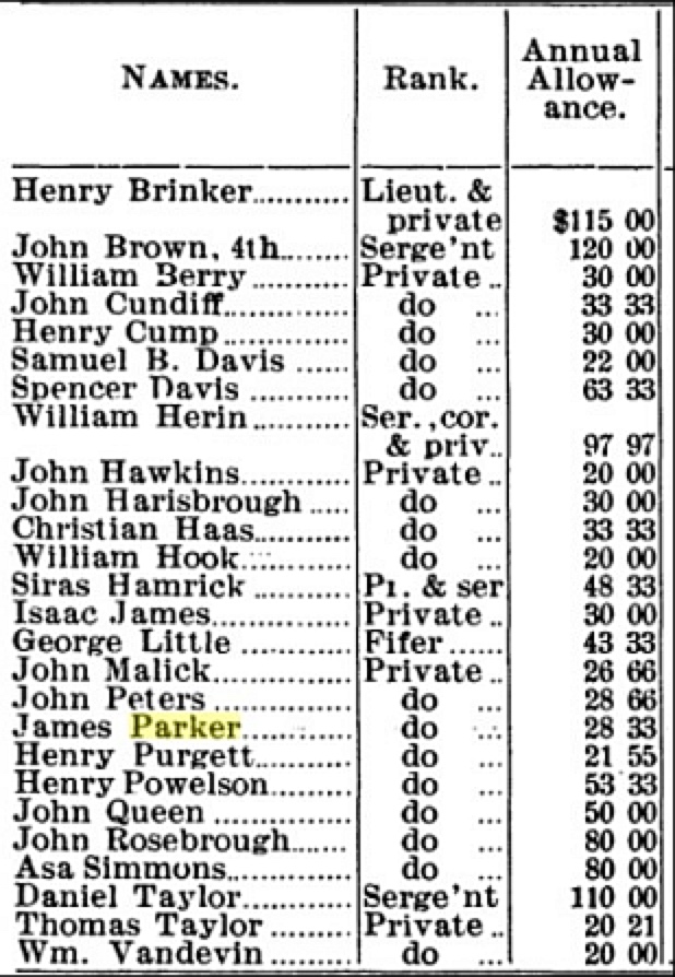
"List of Virginians to received land from Virginia for service in the
Revolutionary War; Statement of Hampshire County, West Virginia,
(The Soldiery of West Virginia, in the French and Indian War, Lord
Dunmore's War, The Revolution ... by Virgil A. LEWIS, M. A. State
Historian and Archivist; GoogleBooks page 88)
"During the Revolutionary War, while most Hampshire residents
supported the rebellion, some recent immigrants from England refused to
raise arms against the king. A number of Tories living along the upper
South Branch, including parts of present Hardy and Pendleton counties,
banded together and threatened to join the British army. A nearby patriot
militia quelled this uprising by overpowering the group and imprisoning its
leaders." (Hampshire County @ The West Virginia Encyclopedia)
"At the close of the French and Indian War (1764) the Indians were mostly
driven west of the Ohio River but soon after the beginning of the
Revolutionary War they became allied with the British and began to make
incursions east and south of the Ohio in Virginia. In the year 1777,
Western Virginia became what was then known as 'The Back Door of
the Revolution.' Henry Hamilton, the British Lieutenant Governor at
Detroit, having furnished the Indians with arms and ammunition, incited
them to attack the colonists south of the Ohio River. George Washington,
through the Governor of Virginia asked the various counties of the state to
raise individual companies to keep or drive the Indians west of the Ohio
River. In Hampshire County this task was delegated to Captain
William Foreman, and he raised a company of 45 men. Many of these names are familiar in Hampshire and Mineral
Counties, such as Riser, Wilson, Pugh, Powell and Johnson. Captain Foreman with his men marched through to Fort Henry,
now Wheeling, arriving there on the 15th day of September 1777, just fifteen days after the siege of that fort. On Sunday, the
26th of the month, in the evening a dense column of smoke was seen down the river and the commanding officer thinking that
the Indians had set fire to the abandoned fort at what is now Moundsville, sent Captain Foreman and his Hampshire County
men to investigate the cause of the smoke and to see if any Indians were to be found. No Indians were found and on the next
day the company started to return to Fort Henry. When the troops reached the narrow pass between a steep bluff and the
Ohio River known as McMechen Narrows, they were attacked by the Indians in ambush, and twenty of Hampshire County's
noble warriors fell. This sad event is known in pioneer annals as "Foreman's Defeat", and long was heard the sorrowful story
in the homes of the South Branch and Patterson's Creek Valleys." (WVGenWeb: Mineral County; also see, Wikipedia,
• 1861–1865: American Civil War
"Hampshire County figured significantly in the Civil War. While the county’s westernmost section was largely pro-Union (in
1866 that section broke off and became Mineral County), most Hampshire Countians sided with the Confederacy. Divided
loyalties, along with the presence of the Baltimore & Ohio Railroad at the county’s northern border, rendered Hampshire a
fiercely contested territory. The frequent presence of Union and Confederate troops led to continual clashing, including major
skirmishes at Hanging Rocks and Blue’s Gap. Romney, owing to its strategic location on the much-used Northwestern
Turnpike (now U.S. 50), changed hands many times during the war, with the total number usually set at 56. In June 1866,
Romney’s Indian Mound Cemetery hosted one of the nation’s first grave-decorating ceremonies honoring the Confederate
dead. In September 1867, the same cemetery became the site of an early monument for fallen Confederate
soldiers." (Hampshire County @ The West Virginia Encyclopedia)
• Additional Resources
• BOOK: "The Soldiery of West Virginia, in the French and Indian War, Lord Dunmore's War; The Revolution; The Later Indian
Wars; The Whiskey Insurrection; The Second War with England; The War With Mexico, and Addenda Relating to West
Virginians in the Civil War." by Virgil A. Lewis, M.A., State Historian and Archivist, Third Biennial Report of the Department of
Archives and History, State of West Virginia, 227 pp. Published: 1911 Reprinted: 2006, GoogleBooks