WEST VIRGINIA Index: Hampshire History, PARKERs, PARKER Timeline, PARKER Map
↳ General History, Early Settlers, FAIRFAX Grants, Life and War
On this page: FAIRFAX Land Grants, (George WASHINGTON as Young Surveyor for Lord Fairfax), Additional Resources
Latest update: Sunday, October 7, 2012
Learn more about our PARKERs in the Family Tree Database .
NOTE
Although WEST VIRGINIA is used on this webpage for convenience,
WEST VIRGINIA was part of VIRGINIA until June 20, 1863.
[editorial comment]
• FAIRFAX Land Grants, circa 1748
BOOK: Early Land Grants and Settlers Along Patterson Creek by Charles Morrison, West Virginia History
A copyrighted publication of West Virginia Archives and History, Volume 40, Number 2 (Winter 1979), pp. 164-99
[excerpted and edited]
[quote]
In 1745 these valleys, north of a line surveyed between the sources of the Potomac and Rappahannock rivers, became part of
a vast proprietary grant, known as the Northern Neck. This included all of the Patterson Creek Valley. The grant was an old
one [The Fairfax Grant], having been made by Charles II in 1649, while in exile, to several his friends and supporters,
including two members of the prominent Culpeper family. Over the years the Culpepers acquired the entire interest, and then
through marriage it passed to the equally prominent and more enduring Fairfax family. In 1719 this royal grant was inherited
by Thomas 6th Lord Fairfax.
There were settlers along Pattersons Creek when Genn first visited it in 1747. [Early settlers included our George
PARKER.] Next year, when he returned to continue his surveys for Lord Fairfax, he brought with him, in addition to his
surveyors, two youthful observers. One was George William Fairfax, son of the Proprietor's cousin; the other one was
George Washington, a friend of the younger Fairfax. [George Washington: Surveyor and Mapmaker, George Washington's
Surveys in Hampshire County, The Frontier Surveyor, History Corner: George Washington (1732-1799) Surveyor and
Cartographer, George Washington's Headquarters in 1747 as Boy Surveyor for Lord Fairfax (page 52, Archive.org)] The party
was on its way to the South Branch of the Potomac by way of Cresap's trading post in Maryland.
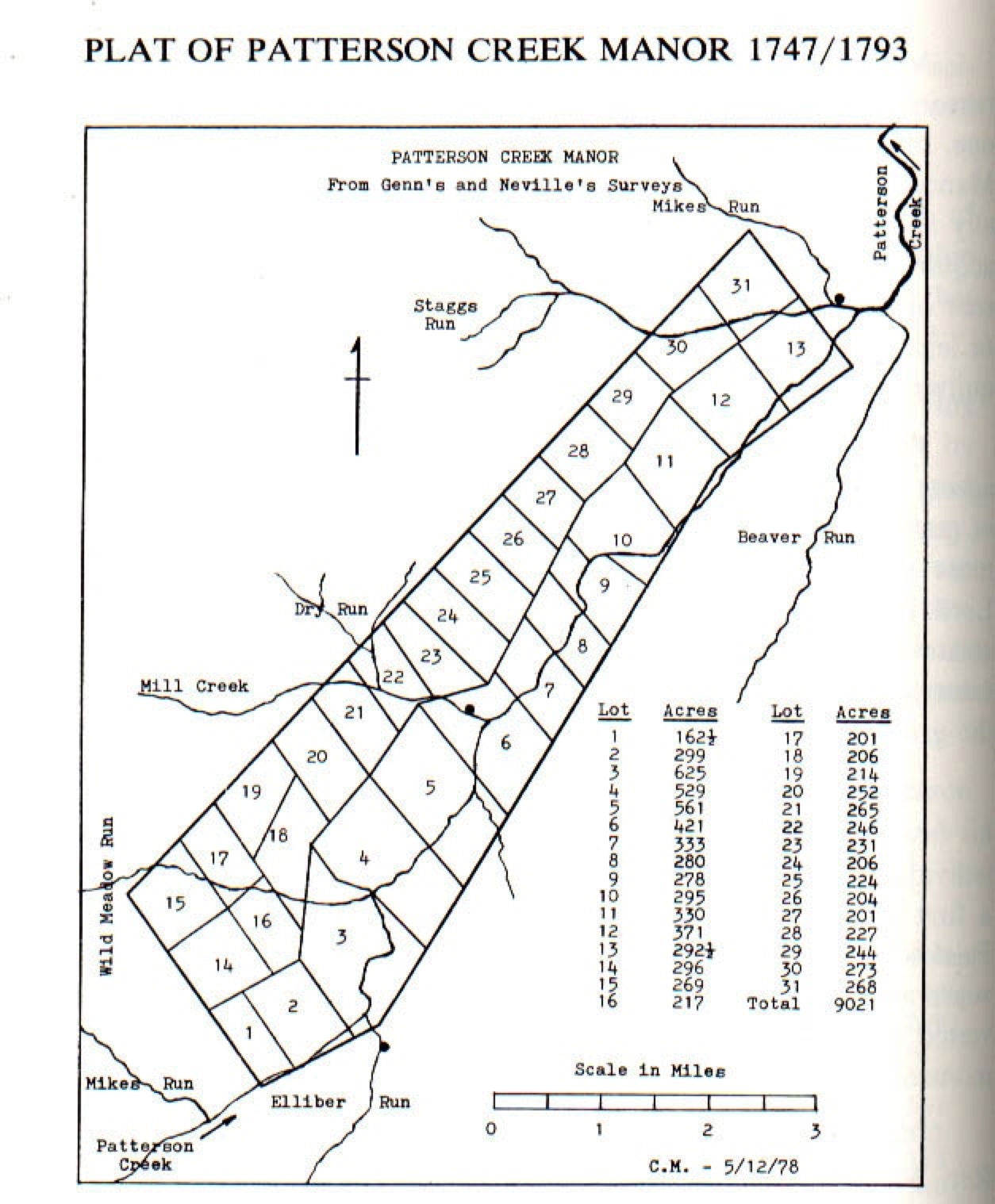
Sixteen lots were granted in 1748-49, as follows. These are recorded in Northern Neck Grant Book G, now in the safekeeping
of the Virginia State Library at Richmond. [Northern Neck Land Proprietary Records, BOOK: Documents relating to the
boundaries of the Northern Neck (1920)]
GRANTS ON PATTERSON CREEK BELOW (NORTH OF) THE PATTERSON CREEK MANOR
John Adam Long, 293 acres, Lot No. 2, Oct. 2, 1748
Capt. John Greenfield, 200 acres, Lot X, Oct. 7, 1748
Nicholas Reasner, 277 acres, Lot No. 3, Oct. 23, 1748
George Parker, 399 acres, Lot No. 1, Oct. 25, 1748
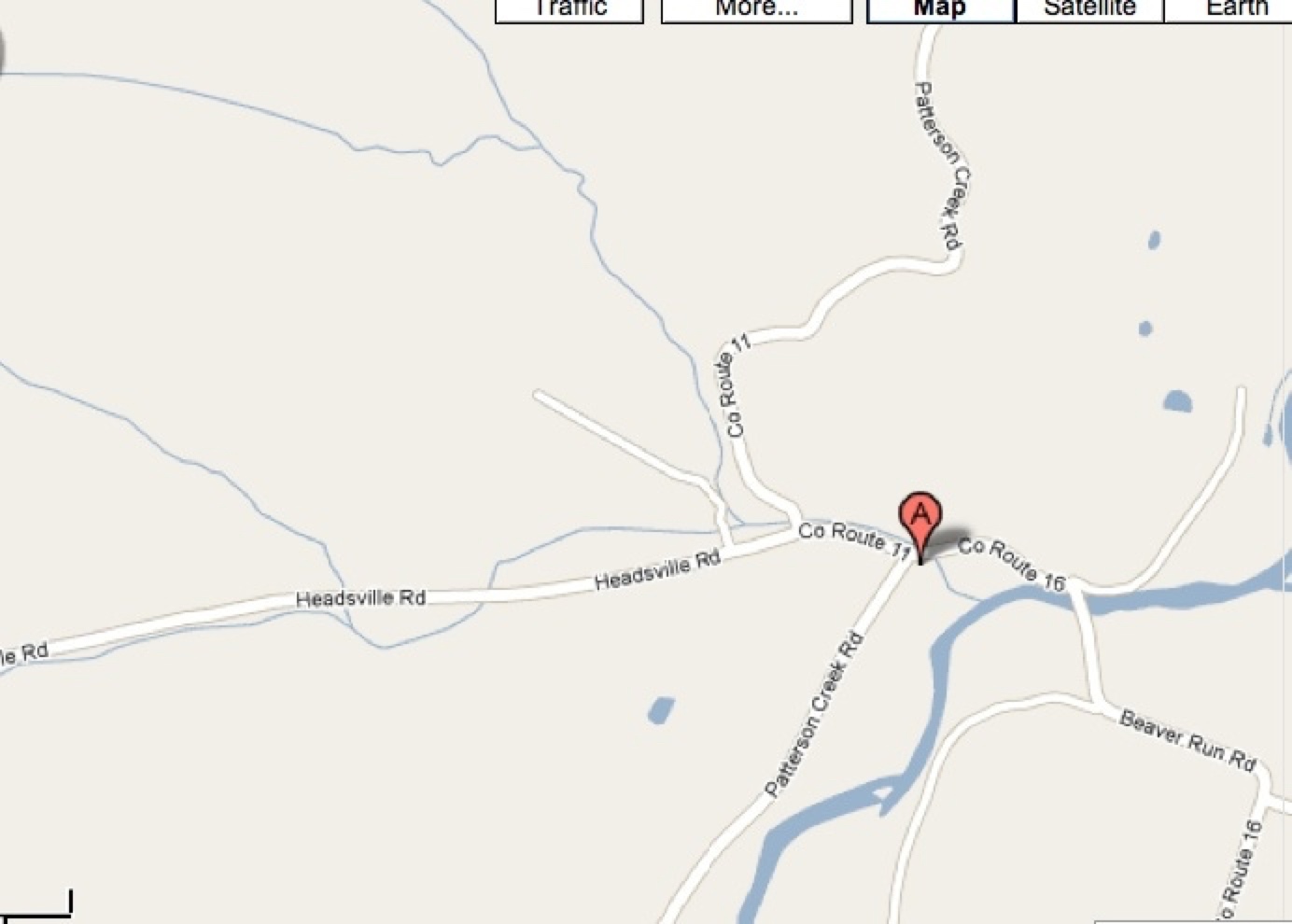
Lot No. 1 [George PARKER lot] was adjacent to the northeastern boundary of the Patterson Creek Manor,
at the present village of Headsville.]
John Ratan, 354 acres, Lot No. 4, Oct. 25, 1748
Abram Johnson, 293 acres, Lot No. 5, Oct. 26, 1748
Power Hasel, 328 acres, Lot No. 8, June 3, 1749
Joseph Hamlin, 289 acres, Lot No. 11, June 7, 1749
John Parker, 312 acres, Lot No. 12, June 8, 1749
Mathew Rogers, 379 acres, Lot No. 13, June 10, 1749
Jacob Good, 394 acres, Lot No. 13, June 11, 1749
Philip Martin, 283 acres, Lot No. 22, June 11, 1749
Joseph Robinson, 332 acres, Lot No. 21, June 11, 1749
Joseph Walter, 238 acres, Lot No. 15, June 11, 1749
Nicolas Crist ,167 acres, Lot No. 10, June 22, 1749
David Thompson, 312 acres, Lot No. 6, June 22, 1749
Proprietary non-manor lots were numbered from 1 at Headsville along the manor line to 22 at the mouth of the Creek. The
numbers were consecutive except for a lot designated X at the mouth of Cabin Run, between the numbered lots 5 and 6. Lot
No. 16 was the site of Fort Ashby (Frankfort on the map). The lots generally extended on both sides of the Creek. However,
Lots 18-22 bordered on the west side of the Creek. The Patterson Creek surveys, like those on the South Branch, sometimes
were made in confirmation of a claim by an occupant already settled on the land. Generally the claimant had marked out about
four hundred acres by blazing trees. Sometimes called tomahawk claims , they were usually respected by their neighbors and
recognized by the Crown or the Proprietor unless there was a conflict.
As an indication of the frontiersman's attitude towards the formalities with regard to land records, it may be pointed out that
Sims Index of Land Grants in West Virginia does not include any of the early Fairfax grants that have been listed. Prior to the
before that in Augusta County. Sims includes these two counties in his Index, but the names listed above do not appear. Like
most holders of Fairfax grants, the grantees were content to have their deeds recorded in the Northern Neck land office and
nowhere else; or perhaps they were unaware of any distinction. Even more likely they were not concerned as long as they
were not disturbed.
1. Plat [to the left; click for larger photo.] drawn from Genn's survey, 1747, and
Neville's plat, recorded September 7, 1793.
[See Early Settlers of Patterson's Creek for additional map.]
2. Stream names are as shown on recent maps of the U.S. Geological Survey.
3. On Neville's plat Wild Meadow Run is Hamptons Run: Mill Creek is Ed. Corns Run and
Staggs Run is Parkers Mill Run. Other tributaries appear on Neville's plat, many unnamed.
However, from the east a Meadow Run joins the Creek within Lot No. 7; from the west,
Hoglands Run flows through Lots No. 24, 25, and 7 to join the Creek on the boundary between
Lots No. 7 and 8. Across the flood plain the courses of some of these tributaries have changed
since Neville's plat was made.
At Headsville, just below the northeast manor line, Staggs Run, joined by another Mikes Run, empties into the Creek from the
west; together they drain a considerable area. Staggs Run may be the Parkers Mill Run which appears on Neville's plat...
Below Headsville the Creek meanders along a generally northern course to the village of Reese's Mill. Here it is joined by an
unnamed tributary from the west, which according to an old deed was probably once named Johnsons Mill Run. This is the
area of Abram Johnson's plantation, where Washington spent his first night on Pattersons Creek on his way to the South
Branch.
[Note: The Plat above is of the Patterson Creek Manor; according to this text,
George PARKER's lot was adjacent to the northeastern boundary of the
Patterson Creek Manor, at the present village of Headsville, and Staggs Run
is also known as Parkers Mill Run. Study the Plat and then today's map
(to the right, click for larger photo) of the area around Headsville, Mineral
County, West VIRGINIA to identify George PARKER's lot.]
During the years following 1748 more and more settlers arrived. As the land along the Creek was preempted by the earlier
arrivals, some found land to suit them along the larger tributaries like Mikes Run and Cabin Run. Some leased a part of their
land to less permanent families. There were mortgages, assignments, and conveyances by lease and release, all of which
suggests that there was a measure of instability within the pioneer settlements - a restlessness that sent many to the south
and west of Pattersons Creek. As a result, others, with the means at their disposal, were able to buy up land in several areas,
which they subdivided and sold or leased later.
Until 1754 Indians moved along the streams and across the land, not in large numbers and not with seeming hostility. Rather
they seemed to believe that they too had a share in the land and its bounty. These were Shawnee, whose tribes had not been
a party to the Treaty of Lancaster, whereby white settlements were permitted as far west as the top of the Alleghenies.
The year 1754 marked the commencement of hostilities between the French and the British over the control of the trans-
Allegheny country. The French sought to establish a line of fortifications and communication between Canada and Louisiana;
the English, particularly those with interest in Virginia, wanted no such infringement on their claims. By its earliest charter the
colony was to extend west and northwest to the farthest sea.
• Additional Resources
• The Fairfax Grant at VirginiaPlaces.org
• BOOK: "Men and Manors In the South Branch Valley" by Sara Stevens PATTON, WV Genweb
• BOOK: "Fauquier During the Proprietorship" byHarry Connelly GROMME, GoogleBooks
• BOOK: "Virginia Northern Neck Land Grants, 1742-1775, Volume 2" by Gertrude E. GRAY, GoogleBooks
• BOOK: "Dividing the Land: Early American Beginnings of Our Private Property Mosaic" Issue 238 by Edward T. Price,
• BOOK: "History of West Virginia, old and new, in one volume, and West Virginia biography, in two additional volumes" by
James Morton Callahan, 1923, Archive.org